After 2 years of not getting away on a trip, we finally made plans to road trip over to Washington's Olympic Peninsula. The ultimate goal was to get to Port Angeles and use it as a base to explore a little bit of the area with the family. But first we had to get there. Along the way we planned on visiting with friends, and of course, to visit some new lighthouses and add to our Lighthouse Passport book collection.
After leaving a friend's house near Tri-cities, we took the lesser traveled WA-410 and were treated to a nice peaceful early morning drive, with a gorgeous view of Mt. Rainier.

We continued our drive, stopping when necessary for the kids, with the goal of reaching Hansville, by 3:00. Hansville is a small town located on the Northern tip of the Kitsap Peninsula, jutting into Puget Sound.

This small town is where the headquarters for the United States Lighthouse Society (USLHS) is located. It's also conveniently right next door to the Point No Point Lighthouse. The USLHS is the organization working to preserve, protect, and educate the public about all things lighthouse and they manage the passport stamp program. Amber and I being members, we naturally wanted to stop by for a visit and to receive the official headquarters passport stamp.


Point No Point Lighthouse gets its name from Lieutenant Charles Wilkes, when in 1841, thought the location was a prominent point in Northwest Puget Sound. After further exploration, however, he realized it was quite small. The name "Point No Point" stuck. the US Congress appropriated funds for the lighthouse in 1873, and by early 1880 the lighthouse was operational. The lighthouse featured a 30 foot tower with a duplex building for the keepers.
Point No Point is the oldest lighthouse in Puget Sound, and it still shines today; although the lamp in the Fresnel lens has been replaced with a modern optic. Today the USLHS occupies one half of the keeper's duplex, and the other half is used as a vacation rental.

The kids enjoyed the beach for a while, before we got back on the road again. We made a quick stop to try and get a view of a private lighthouse, Skunk Bay Light, also in Hansville.

Jim Gibbs, a former lighthouse keeper, was able to rescue the lantern from the Smith Island Lighthouse before it fell into the waters of the Strait of Juan De Fuca, and he incorporated it into a private lighthouse he built on his property. Eventually he registered the beacon as an official aid to navigation with the US Coast Guard. Today the building is privately owned, but you can get a faint glimpse of it through the dense trees.
We ended out day with a drive across the Hood Canal, and to a quiet vacation rental near Port Hadlock, for the night. We would be well positioned for our bigger adventures the following morning. It was in a perfect location: Away from any main road, almost no sounds except the birds and occasional airplane, and a nice view of a small bay where we could watch the tide come and go.
In the morning we were up and made the thirty minute drive North to Port Townsend. On the far northern tip of the peninsula sits Fort Warden State Park, and on the edge of this park sits Point Wilson Lighthouse. All ships turning south into Puget Sound must pass by this point, in the channel between Point Wilson and Whidbey Island into what is known as Admiralty Inlet.

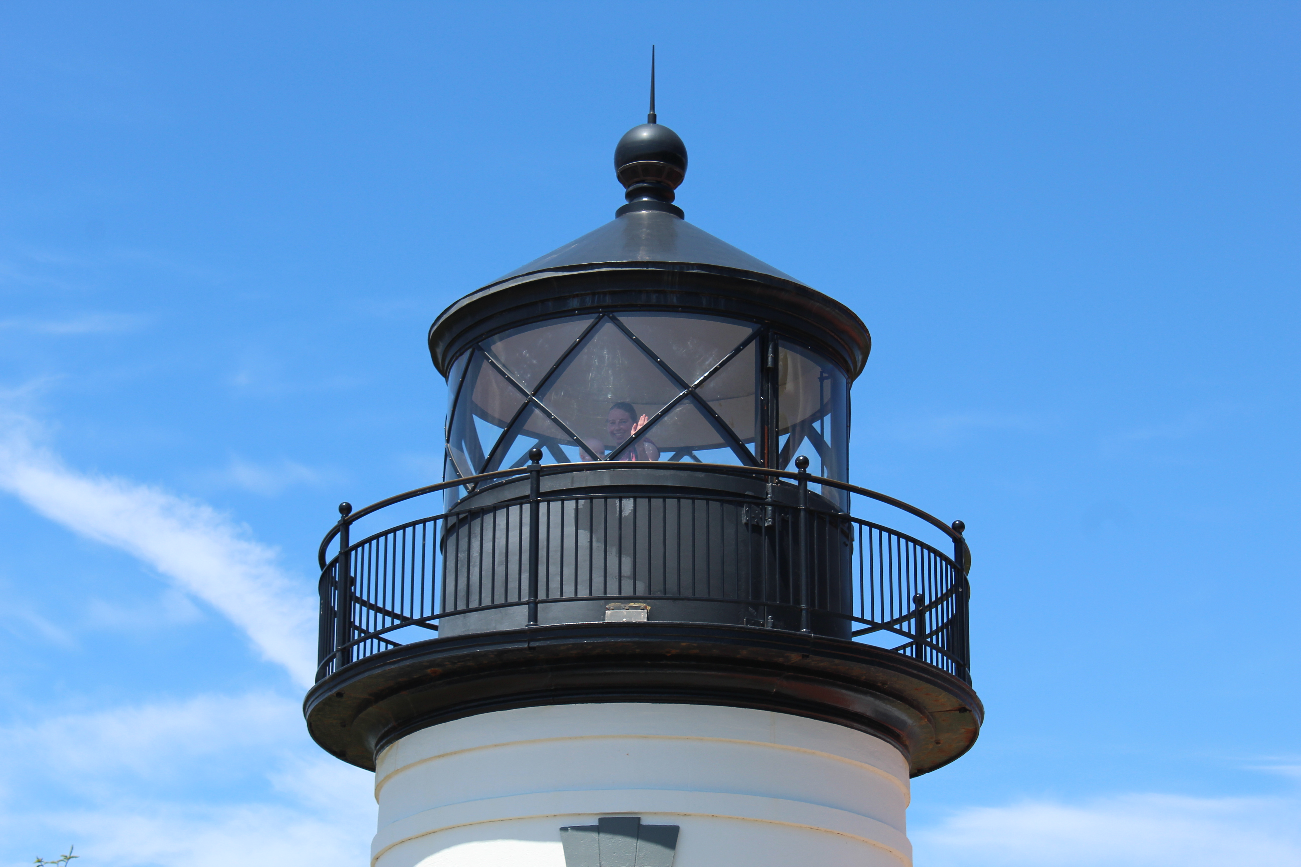
The Point got its name when George Vancouver bestowed it in honor of Captain George Wilson. The 1 1/2 mile sand spit naturally is a hazard to shipping turning south, so Congress appropriated funds and in late 1879 Point Wilson Lighthouse and fog signal went into service. The original tower was a 46 foot tall wooden tower that was incorporated into the roof of the keeper's dwelling. Contained in the lantern was a fourth order Fresnel lens with a fixed light.

(Original light built into keeper's dwelling, with newer light in the background)
In 1894, the fixed lens was replaced with a rotating fourth-order Fresnel lens. Beach erosion continued to threaten the light, so in 1914 the new lighthouse was built farther back. It was a 49 foot tall concrete tower with an attached fog signal building. This is the current light that stands today. The keeper's dwelling and support buildings are still there (keeper's dwelling is a vacation rental) but the tower has been removed from the dwelling.

For the Point Wilson Lighthouse, I was able to arrange for a private tour. Our docent met us at the lighthouse and shared with us the history of the point, lighthouse, and then we got to go inside and climb the tower.


We found out that the day before, the USLHS that is managing the restoration of Point Wilson, just finished restoring and relit the Fresnel lens. Once again, it is an active navigation aid.
After our tour had finished, we made our way to the Port Townsend Ferry Terminal. I had made round trip reservations for a day trip to the Coupeville landing, on Whidbey Island. It would be a short 30 minute trip, and then we'd have 4 hours on Whidbey, before returning to Port Townsend.

The plan for the afternoon was to just have a relaxing time exploring Fort Casey State Park, which is located right next to the Coupeville ferry landing. Fort Casey is mostly a military fortification park, and it also encompasses the Admiralty Head Lighthouse.
The East side of Whidbey Island juts into Admiralty Inlet, so in 1858 the Feds bought some property with plans to construct a lighthouse. The first lighthouse went into service on January 21, 1861. It originally had a fixed white light, with a fourth order Fresnel lens. In 1901 the US military established Fort Casey as one of the many coastal defense forts built in the Puget Sound area. As a result, the lighthouse was moved a little bit to the North, and the current one that stands was constructed.

It's life was short lived, however. By 1922 the shipping traffic would stay close to the Western shore, and as a result Admiralty Head Light was deemed unnecessary and was deactivated on July 1, 1922.

The rest of the afternoon we explored the old bunkers, gun emplacements, and abandoned buildings left over from the military days. After WW2, the forts all along the coast were abandoned as technology had progressed and made them obsolete. That evening we made it to Port Angeles and the rest of the trip was spent exploring a little bit of Olympic National Park (the less crowded, free areas), taking the kids to a marine center with touch tanks, playing on the beach, exploring some old growth forests, a timber museum, and visiting with friends.
I had wanted to take the family out to Cape Flattery. It's the most Northwest Point in the lower 48, and after a short hike you can see, in the distance, the Cape Flattery Lighthouse, perched upon Tatoosh Island. The round trip distance, however, forced us to change plans since our youngest, Carson, was already enduring a lot of carseat time.

Definitely want to take more trips to Western Washington. There's so much more of the Olympic Coast to explore, more lighthouses, and many more adventures. I think I need to wait for the kids to get a bit older before we attempt another trip over there, though...