Tuesday, December 10, 2019

Fur Trading & Last Oregon Lighthouses

The first weekend in December yielded warmer weather, albeit rain, and we managed to slip out of Pasco for a 3 day weekend.  We were headed to Harrisburg, Oregon, near Eugene, to visit and stay with some of Amber's friends for the weekend.

Friday morning we headed out through dense fog and decided to drive on the Washington side of the Columbia River, on Hwy 14, all the way to Vancouver.  The Washington side is very peaceful and quiet, compared to the craziness of Interstate 84 on the Oregon side.  We had never driven this entire stretch, so it was a chance to cover some new ground.

Upon arriving in Vancouver our stop was Fort Vancouver National Historic Site.


Fort Vancouver was established by the Hudson Bay Trading Company, a British entity, in an effort to cement British control over the disputed Oregon Country.  It was the major hub for economic & social policy in the Pacific Northwest, at its time.  John McLoughlin was the primary overseer and tasked with maintaining the fort and keeping out American settlers.  As more settlers poured over the Oregon Trail, however, this became an impossible task.  Great Britain did not want to fight a 3rd war with the United States and eventually ceded the Oregon Country to the U.S. along the 49th Parallel.  This left Fort Vancouver suddenly in the center of the United States.  The fort continued to operate in subsequent years, but its decline was inevitable.  It was ultimately taken over by the military.

Today the fort's buildings and stockade walls have been reconstructed in their original locations.  We toured the grounds of the fort, and got some live demonstrations from blacksmiths working with era tools & materials.

The park features more buildings including a small air museum at Pearson Field (which we explored), and other military barracks and buildings (that we didn't have time to check out).


After our time at Fort Vancouver, we continued south to Harrisburg.  Amber was attending a Christmas party with her friends Evan & Adrienne and I rolled solo for the night.  The next morning Adrienne joined us to make a quick trip over to Newport, on the Oregon Coast.

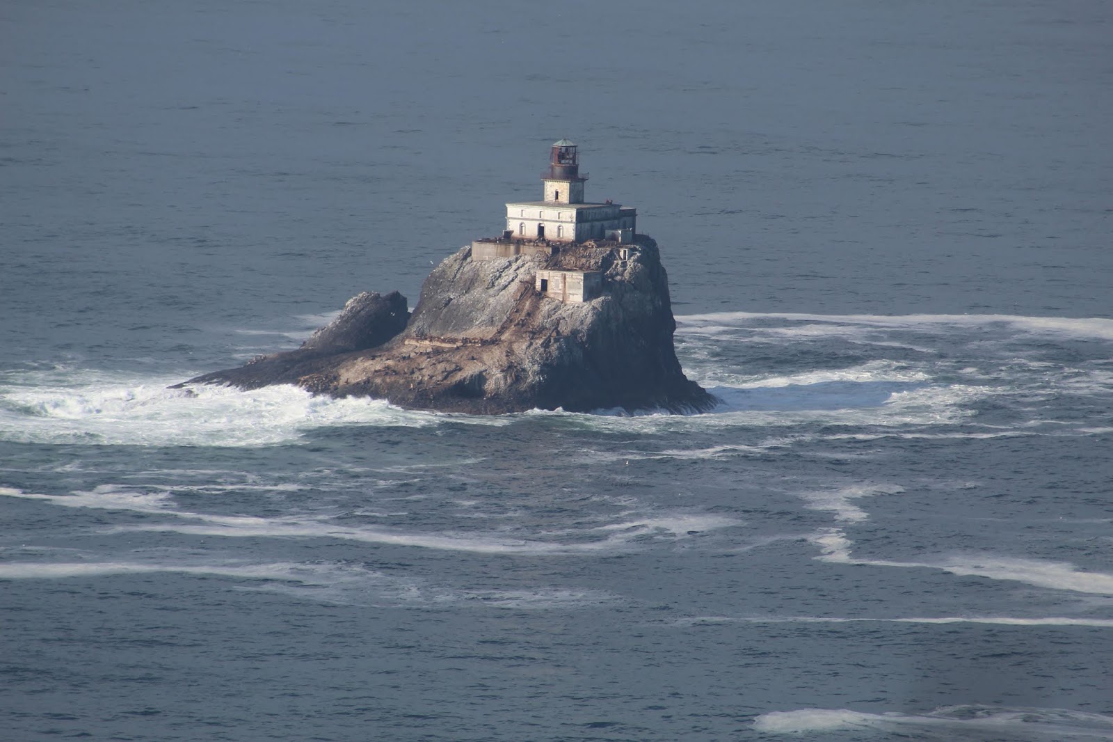
Our main reason for heading to the coast was to get the stamps in our lighthouse passport book for the Yaquina Head & Yaquina Bay lighthouses.  We had visited before, but also never been able to do tours inside.  This trip, however, would fix all that.  The three of us visited Yaquina Head Lighthouse first.  It was first lit in 1873 and had a first order Fresnel lens.  While we waited for our tour we explored the Interpretive Center, and then I braved the rain and hiked around on a beach and took some pictures.


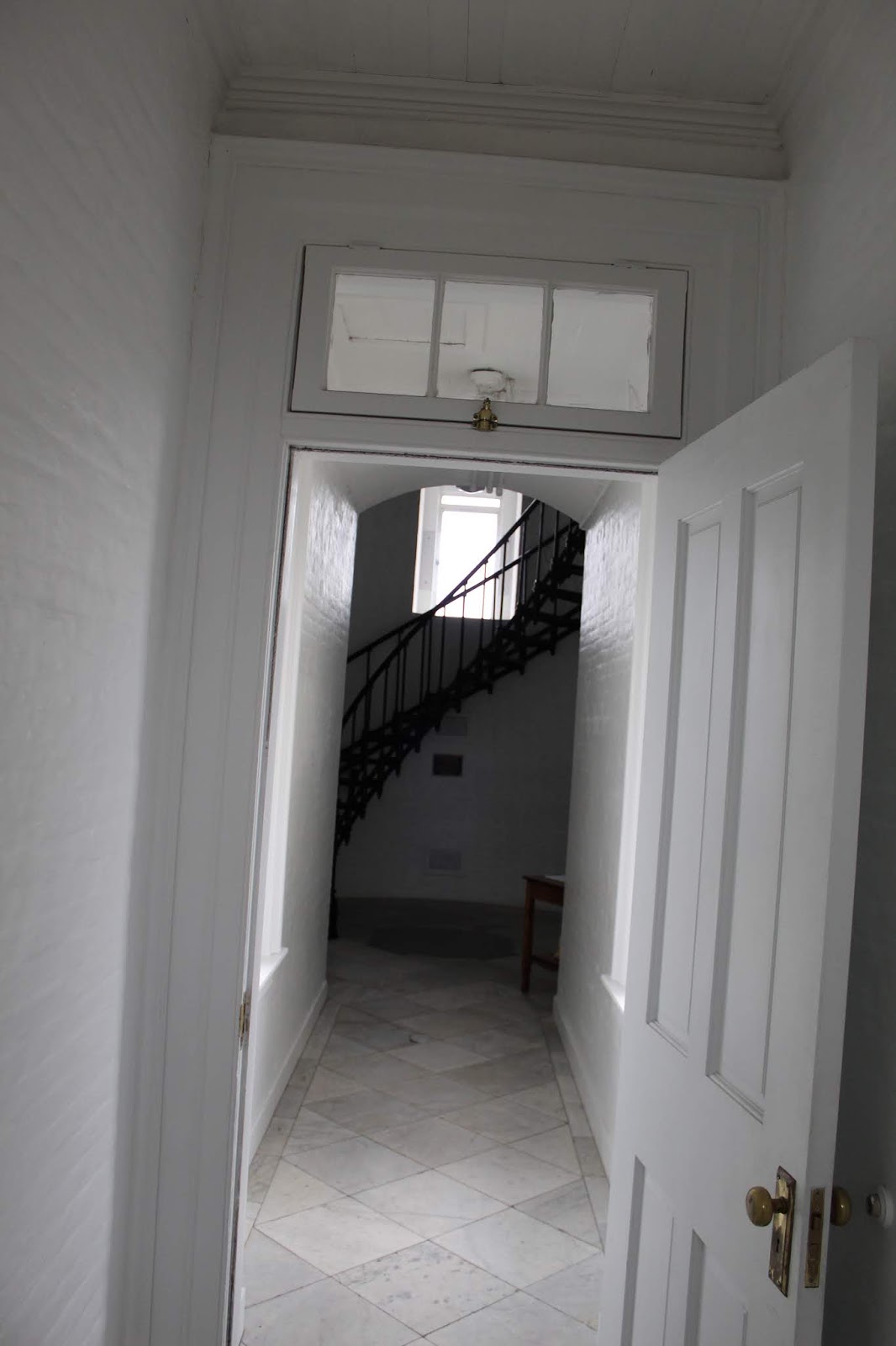
When the tour began we were all glad to get out of the wind and rain and be let inside the lighthouse.  We started gathered in the old oil storage room, then transferred to the keeper's office quarters, and finally topped it off with a climb to the top of the tower.


When we finished up our tour of Yaquina Head Lighthouse, we headed back into Newport to visit the Yaquina Bay lighthouse.  Amber and I had seen it from the outside on our honeymoon, but this time we were able to go inside and do a self guided tour and get our passport stamp.

Yaquina Bay Light was built in 187, and it was decommissioned in 1874, only operating for three years.  The bay lighthouse was difficult to spot by ships approaching from the north, so the Yaquina Head lighthouse was the solution.  It became obvious pretty quickly that having both lighthouses manned would be a waste of resources, so it was shut down.


Our last stop was downtown Newport to grab a filling late lunch of seafood at the local Mo's, before we drove back inland to Harrisburg.  Amber and I spent the evening with Evan & Adrienne again before we drove back to Pasco the next morning.

Sunday, October 27, 2019

Ginkgo Petrified Forest

Amber and I set out for a Saturday adventure to a Washington State Park only 1 1/2 hours from Pasco.  I've driven by it numerous times, but this was our first time to visit what is called Ginkgo Petrified Forest State Park.


It can be difficult to sort out the things that obviously don't line up with a Biblical timeline of the earth's age, but the park nonetheless gives you a fascinating perspective into what Eastern Washington used to be like.

At some point in the past, Eastern Washington used to be a more lush landscape.  At that time the Cascade Mountain Range either didn't exist, or they were much lower and the moisture wasn't prevented from reaching the interior as it is today.  It would have been a landscape of tall forests, lush plant life, swamps & bogs, and more.  Scientists believe that the area today preserved as the state park was probably a log jam instead of an actual grove of ancient trees, due to the immense spectrum of tree species that have been discovered (Possibly a result of Noah's Flood, I can't help but wonder). 

Today petrified elm, oak, douglas fir, redwood, sweet gum, walnut, and of course the park's namesake ginkgo have all been found here.  It is unlikely that all this variety grew in this one location.


At some point after this the series of cataclysms that shaped Eastern Washington into what we know today, began.  It's just my opinion that, based on a post Noah's Flood world, the resulting events happened.  Plate tectonic forces were created after the "fountains of the deep" broke open.  That led to the creation of the Cascade Mountain Range.  Lava spewed all across the Pacific Northwest.  As the mountains got higher, the interior became drier.  Scientists think that as the lava poured across Eastern Washington, the big log jam at Ginkgo State Park was protected from the lava by the bog environment.  The lava cooled rapidly from the high water content and effectively sealed the logs underneath.

As layer upon layer of lava continued to pile up, minerals percolated down to the logs and the process of petrification began.  The lack of oxygen allowed the minerals to penetrate and transform the logs into stone.  Today they are solid rock, but retain their wood grain structure.


At some point another great change in Earth's history occurred.  Again, it's my opinion that in the post flood world one of the results was the ever changing weather and climate.  We still feel the effects today, but not as extreme as right after the flood.  The evidence is undeniable that great ice ages did occur: scientists just don't agree on the timeline of them.  I prefer to look at it from a biblical perspective, of course.

In this new frozen world of North America, giant ice dams were formed.  All across Washington, Idaho, and Montana the evidence of this lake/lakes can be seen.  As the lakes filled up the ice dams eventually broke, resulting in massive floods across the Pacific Northwest.  The processes was repeated again and again.  The massive flood waters scoured away the landscape forming the step-lands & coulees all across Eastern Washington.


How does this relate to Ginkgo Petrified Forest?  It just so happened that as the flood waters stripped away the deep layers of basalt laid down by the volcanic eruptions, they eventually cut down to the layer in which the preserved trees were buried.

Fast forward to 1927 when construction workers who were working on building highways noticed exposed sections of the petrified trees.  This led to further scientific study and excavations.  During the Great Depression the Civilian Conservation Corps handled a lot of the excavations, trail & museum building, and opening the area up to the public in 1938.  Today is is much the same and you can come and tour the landscape and get a glimpse for yourself into Washington's fascinating history & geology.

And of course, this only wets my appetite for discovering more about Eastern Washington's unique topography and seeing more of the landscape that was sculpted by this immense floods that probably occurred at the same time many of the stories in the Bible were taking place.  I'm sure there will be more adventures into the dry interior of Washington to come...

Monday, October 14, 2019

Mouth of the Columbia River

This past weekend, Amber and I were up at 4am to do a quick trip out to the Pacific Ocean.  We left Pasco, and it took us a little over 5 hours to get to Astoria, Oregon.  Astoria sits right by the mouth of the Columbia River and is known for being the oldest settlement west of the Rocky Mountains.  We had two main goals for our quick weekend trip. 1. See every lighthouse in the area and get our USLHS Passport stamps, and 2. See more Lewis & Clark history.

We started off by heading to Cape Disappointment, on the Washington side of the river's mouth, first.  In 1856 the first lighthouse, known as Cape Disappointment Lighthouse, was built.


The light was needed to help mark the entrance to the Columbia River.  According to somebody above my pay-grade, the Columbia River Mouth is the 2nd most dangerous in the world.  The only one more dangerous is the mouth of the Amazon River in Brazil.  Because the Columbia carries so much silt and sediment when the river meets the Pacific Ocean it drops immense amounts that create ever changing sand bars.  These changing conditions combined with frequent storms create treacherous conditions for ships.  Over 2,000 ships have sunk in these waters off Oregon/Washington, earning it the nickname "Graveyard of the Pacific".

The new lighthouse certainly helped, but it could not be seen around the headland by ships approaching from the north.  To solve this problem, a second lighthouse was built on Cape Disappointment just 2 miles away as the crow flies.  It is known as the North Head Light.


After checking out the lighthouses, we crossed back over into Oregon to explore some more Lewis & Clark sites.  On their arrival to the Pacific, they combed over the whole region surrounding the mouth of the Columbia River.  For days they endured bad weather on the Washington side, until they made the decision to cross south and built a fort in which to spend the winter.  This fort was named Fort Clatsop, after a local Indian tribe.  They spent December o 1805 to March 1806 in this location.  Today, Lewis & Clark National Historic Park preserves the area they wintered, and a replica of Fort Clatsop stands, based on drawings and dimensions laid out in Lewis's journals.


We watched a film and explored the exhibits and some trails before continuing on our day of adventures.  We opted for Fort Stevens State Park.  It was created to preserve beaches and military installations.  Lots of bunkers, gun emplacements, and radar stations are all over the place.  They date back from the Civil War era up to World War II.  In addition, Fort Stevens is the location of a Japanese submarine attack during World War II.  The sub launched about fifty shells against the area before slipping away at night.

Amber and I had time to check out one of these emplacements, but our real focus was seeing Oregon's most famous shipwreck.  It was called the Peter Iredale.  She was a British steel sailing vessel enroute to Portland.  On October 25, 1906 she was waiting out a fierce storm that prevented her from entering the Columbia River.  The ship was driven ashore and became stuck in the sand due to the storm.  No lives were lost, but the ship was abandoned.  As a result it quickly became a tourist attraction.


At this point in our evening, we were about ready to call it a day.  We made a run to get gas and some candy before checking into our Airbnb room for the night.  We heated up some dinner, showered, and slept for about 10 hours that night.

The next morning we really only had one main goal for the day: Try to get a view of Tillamook Rock Lighthouse.  It was the last Oregon Coast lighthouse we had yet to see and get a picture of.  I had tried in 2012, but the viewing was obscured by the all too common bad weather.  It is a mysterious sentinel isolated over a mile offshore.

We headed down to Cannon Beach and attempted to find a historical marker/monument about the "Salt Works" where the Lewis & Clark expedition had sent men to boil sea water and obtain salt for their return in the spring.  But we couldn't find it, so we continued on.  We arrived in Cannon Beach and made the windy drive up to Ecola State Park.  Our plan was to hike Tillamook Head.  This was the farthest south Lewis & Clark explored, and he described Tillamook Head as one of the steepest hills he had ever climbed (funny since he crossed over the Rocky Mountains and they were much worse).

It was a gorgeous morning for a hike, and it was neat to think we were once again walking in the footsteps of the famous expedition.  At the top of the head we hiked a short spur trail and were finally rewarded with the view that I had wanted to see for years...


The Tillamook Rock Lighthouse was another aid to Columbia River navigation and it was finally lit for the first time in 1881.  The construction, upkeep, and stories surrounding this remote lighthouse is quite a remarkable story, surrounded by both fact and legend.  But it took workers 7 months alone just to level the top of the rock on which to build the lighthouse.  They were stuck on their island prison the entire time.  They lived in tented bolted to the rock and endured countless fierce storms.  Once the lighthouse was completed it quickly gained the nickname "Terrible Tilly" due to the horrible and lonely conditions.  The fierce winter storms routinely drove waves over the top of the lighthouse.  Supply runs were not consistent due to constant bad weather.

The lighthouse was deactivated in 1957.  Today it sits abandoned and decaying 1.2 miles offshore.  More often than not it is shrouded in fog and secrecy.  Being able to view it today finally meant that Amber and I had officially seen every lighthouse on the Oregon Coast.  We went into Cannon Beach to get out Lighthouse Passport Stamp, and then began the drive back to Pasco....

I will close this post with a video shot I was able to get with our camera.  I'm quite pleased with the quality considering the great distance offshore this lighthouse really is.


Friday, September 27, 2019

Manhattan Project National Historic Park: Hanford, Washington Unit

The last full day that Emily visited us, we decided to pay a visit to the Manhattan Project National Historic Park, Hanford Unit.  This National Park site is unique because it is composed of three different sites all related to the creation of the atomic bombs during World War 2.  There is a section in Los Alamos, New Mexico, Oak Ridge, Tennessee, and this third site at Hanford, Washington.

In Richland the park has a visitor center that you start at.  We had signed up for a 9am tour of the "B Reactor".  We started out watching an orientation film about the history of Hanford, and got some basic information from our tour guide before we were loaded up onto a bus and driven 40 miles out onto the restricted site.  The Department of Energy still manages the entire Hanford Reach area, but clean up and tourist development has allowed some areas to be opened up.


The original facilities (including B Reactor) at Hanford were built in 1943 for the purpose of large scale, massive plutonium production.  This lonely stretch of Eastern Washington was chosen for its isolation, plentiful supply of electricity from nearby hydroelectric dams, a large supply of water from the Columbia River that would be needed to cool the reactors, and other reasons.  A massive construction project was organized to develop the site and a lot of those stories can be told on another tour the NPS does of the historic buildings that remain from the actual town of Hanford.


Despite the lack of population, there were still people who were displaced from their land by the federal government.  Most of them were given very short notice and were not fairly compensated for their land and lives being uprooted.  Once we began getting close to the "B Reactor" location, you could see one of the original homestead buildings that still remains.  In all, white settlers from the towns of Hanford, White Bluffs, and American Indians were all displaced from their homes as it was deemed "necessary" for the war effort.


Upon arriving at the front of the B Reactor you step off the bus and you immediately see how massive the facility is.


We were directed into the biggest room in the reactor facility where staff sit everyone down in chairs and give presentations, attempted to explain the chemistry behind plutonium production.  As they talk to you, you are right in front of the loading tubes (2,004 of them, to be exact).  Uranium 235 fuel was loaded into each one of the tubes at at different stages to begin the reaction process.


High pressure water was directed into each tube in order to provide cooling.  It took about 1 second for the water to travel the entire length of tube.


Without getting too complicated, Uranium 235 was loaded into each tube and graphite jackets surrounding the tubes make the Uranium undergo several chemical changes that produce massive amounts of heat.  Boron control rods were placed horizontally and vertically.  Operators could manipulate these rods to slow or even stop the reaction process.  Eventually the Uranium fuel transforms into Plutonium in limited quantities.  It was this plutonium that the scientists were after in order to fuel the atomic bombs.

Once a Uranium fuel slug was spent it was pushed out the back of the reactor into various chemical and water baths.  Eventually workers would use long tongs to withdraw the slugs and they were transported on a train to a processing plant where the Plutonium was extracted from the fuel.  This facility in Hanford is where the plutonium contained in the atomic bomb dropped on Nagasaki, was produced.  It was so neat thinking that we were standing in a facility that contributed to the end of World War 2.


During the course of our time at the B Reactor we got time to wander some of the other areas like the control room, fan & ducting rooms, and where the water intake into the facility is.


We also learned that we didn't have enough time.  If you try and listen to all the presentations, visit all the areas open to the public, and fully soak in all the information, you won't be able to do it.  I figure it will take at least another 1 or 2 visits to complete the experience just to the B Reactor, not even counting the other Hanford Townsite Tour.  The tour guides throw A LOT of information at you.  Before we knew it we were being herded back onto the bus for the ride back to Richland.

Thankfully the tour is free, but you need advance reservations because the tours usually fill up.  They are generally offered April through November, and the tour dates and times are posted on the park website.  There will definitely need to be another return to the site in my future...

Tuesday, September 24, 2019

A lighthouse and a Mission

Amber and I are officially moved into Pasco, WA, and I have started my new job at Bergstrom Aircraft.  My sister Emily came up to help us unpack and get things organized, so when we were all done we had a couple free days to explore some of the local sites.

We started off our adventures by going to check out the lighthouse on Clover Island.  It's a functioning lighthouse that was built in 2010, and placed on Clove Island, in the Columbia River.  I believe it's technically in Kennewick.  We were also pretty excited to see that the lighthouse has a stamp we were able to add into our United States Lighthouse Society Passport book.


The following morning we packed a lunch and set out for the short drive over to Walla Walla, WA, and the nearby Whitman Mission National Historic Site.


It was a very interesting and tragic part of history to learn about.  The Whitman Mission was founded in 1836 by Marcus Whitman, and his wife, Narcissa.  This was before the mass emigration on the Oregon Trail began so aside from French/Canadian trappers, the Whitmans were some of the first white settlers in the area.

Marcus and Narcissa were both products of the Second Great Awakening that occurred in America.  They both believed they were called to be missionaries for the rest of their lives, and had the conviction to spread their beliefs and way of life.  So they came to what is present day Washington and received permission from the Cayuse Indian tribe to build a mission.  Marcus was a preacher on Sunday and practiced medicine as a doctor during the week.

Life was hard, but the Whitmans persevered in their quest.  They hired what laborers they could to assist with growing crops and constructing buildings.  The Cayuse Indians became receptive to the message that Marcus brought and he regularly preached to them.  Very quickly, however, problems arose due to language barriers, Marcus's way of presenting & preaching, and perhaps most significant- his belief that the Indians and their culture were inferior to all whites.


In today's world it is hard to understand how missionaries could preach the Word of God, but also preach the superiority of their own culture.  Today's Christian missionaries are taught how to assimilate into the people's culture whom they are attempting to reach.  And Scripture is very clear that "God has made of one blood all peoples of the Earth", so there is no room for this intolerance of another culture.

As the Oregon Trail began to receive heavy use and settlers flooded West in ever increasing numbers, the Whitman's Mission began to be a short detour stop for those sick, or desiring some rest before continuing on to Oregon.  The settlers brought epidemics of diseases like smallpox that they had developed resistance to, or the methods used by Marcus to treat patients usually worked on the whites.  But when Marcus attempted to administer aide to the Indians who had contracted diseases, they usually died.  This fueled a mistrust of the Whitmans among a lot of the Indians.

All of these misfortunes of science & medicine, language barriers, and misinterpreting Scripture eventually resulted in the unfortunate massacre that played on on November 29, 1847.  A group of the Cayuse Indians attacked the mission and brutally killed Marcus & Narcissa and nine others.  There were some people who escaped, but the Cayuse ended up taking fifty individuals captive.  It wasn't until a month later that their return was ransomed by the Hudson Bay Company.

This event ignited the Indian Wars in the Oregon/Washington region and was a major driving force behind forcing tribes such as the Cayuse, Umatilla, and others onto reservations.

Today you can tour the land that the Whitman Mission once stood on.  Markers are laid out denoting the main buildings and their dimensions and showing where each of the Whitmans died on that fateful day.


In addition to this, there is a loop trail that takes you to a memorial erected on a hill on the 50th anniversary of the attack, and a location of a mass grave as well.


Overall it was a very interesting visit to another location in our country that preserves tragedy so that we can learn from our ancestors mistakes, and hopefully not repeat them...

Saturday, September 21, 2019

Last Hurrah In Montana Part 4

It was our last day on the road, and we were thinking we would make it home by evening so that we could begin to pack for our big move over to Pasco, WA.  Our only definite plan for the day was to spend some time exploring Big Hole National Battlefield near Wisdom, MT.  It's very close to the Montana/Idaho state line, where the Bitterroot Mountains function as the state's boundary.


Big Hole National Battlefield is part of the famed Nez Perce Trail, and perhaps one of the most important battle sites in the whole trail system.  By this point in the Nez Perce Tribe's flight, in August of 1877, they had already been on the run from the US Military after some skirmishes in Idaho.  Their ultimate goal was present day Wyoming in order to try and seek an alliance and help with the Crow tribe.  After crossing the Bitteroot Mountains they believed they were safe and took this time to rest and relax next to the North Fork Big Hole River.


Unbeknownst to the tribe, the US military had been closing in on their position and planned on trying to scare the tribe into surrender so that they could be forced onto the newly created reservation.  While they were bedded down for the night in their camp, American troops were slowly approaching their camp to try and force the surrender.


Early in the morning one of the tribesmen went to check on the horses grazing on the nearby hillside.  He unknowingly stumbled into the American troops, which resulted in in shots being fired.  In a flash of confusion soldiers began raining fire down upon the camp.  Some women and children were killed right where they slept.  The pushed into the camp with orders to burn the village.

Confusion ensued with small bands of soldiers fighting hand to hand with the American soldiers, while Nez Perce chiefs slowly grasped the situation and organized a counter attack.  They were able to drive the soldiers from their camp and forced them back across the river to a secluded area of trees and cover that would prove more defensible.


An interesting fact to note is that this group of soldiers were the same ones who had reached the battlefield after Custer's regiment had been destroyed in Eastern Montana just a year earlier.  They had seen the massacre and suddenly found themselves in a similar situation.  They frantically tried to take cover behind anything they could.  Some tried to dig shallow trenches with their bayonets, that you can still see to this day.


The soldiers hunkered down while Nez Perce snipers picked them off and continued the assault, until their tribe could withdraw and continue their flight across Montana.  Today a monument stands in the location of this part of the battle.


What does this all mean for us today?  Certainly for history buffs this is an interesting place.  You can study the military tactics, errors, and certainly try and transport yourself back 142 years to the time of this battle, as you stroll through the landscape that has remained relatively unchanged.  It's a very humbling experience to spend time at this place where so much terrible and needless bloodshed occurred.

Before we started our visit, we spent some time talking to an interpreter at the park's visitor center.  We were told just how important it is to not come into learning about this place with a biased view, and I certainly agree.  There is no clear black and white in a lot of our country's history.  On one hand you have the U.S. Government who in most cases broke treaties, lied, and forcibly removed American Indians from their native lands.  In many cases even the military leadership held clearly wrong views of the native people.


But when you delve deeper into the personal accounts you realize how much more complicated these situations are.  Soldiers who are torn between obeying their superior officers and country, and not killing innocent women and children.  There are stories of great moments of compassion, brutality, kindness, and affliction.  Individuals who refused to obey orders for the sake of saving human life, and those who go far beyond "just following orders", exacting unspeakable acts upon the Indians.  There is no doubt that America's policy towards the Indians was wrong.

But then you have to delve deep into the Indian's history as well.  If you strip away the contact with white settlers and study purely their interaction with their fellow tribes, you see that the American Indians were really no different from the whites.  They fought among each other; went to war, pillaged neighboring tribes, killed women and children, etc.  The Nez Perce were actually fairly well despised themselves.  They were the envy of other tribes as they had intimidated and clawed their way into a position of power among their own people.  Did they deserve to be evicted from their homelands?  No.  Were the Nez Perce an innocent people group who had done no wrong and were completely victimized?  That's the tricky question...

What it really comes down to is the depravity of man and our need of a Savior.  Without Christ guiding our lives every day we will fall prey to these blunders in history.  You had two very different people groups each acting in their own interests and customs instead of following the ways of Jesus Christ.  When we act out of selfishness, greed, anger, revenge, or other sinful emotions we hurt ourselves, others, and events like this battle by the Big Hole River occur.