Saturday, May 25, 2019

The End of the Great Plains, and a Humbling Ending

Saturday & Sunday May 18-19, 2019
I want to do this final post a little different than the previous ones.  I'll quickly recount the rest of our trip, and then backtrack a little to our time at Little Bighorn Battlefield National Monument as I believe it is a fitting close to this narrative.

Saturday morning we awoke in Forsyth with fresh spring snow.  For those of you wondering, yes it can snow any time of year in Montana.  We had a great breakfast with Chuck & Kathy before setting out across the vast openness of Montana to visit Little Bighorn Battlefield.  But more on that later.

After our time at Little Bighorn, we made the drive to Bozeman, MT, to stay with my friend Alex, and his new wife Hannah.  It was great to visit with them, and it was our second time meeting Hannah.  They were nice and treated us to dinner before we spent the evening visiting and playing Ticket to Ride Old West.

The following morning we had breakfast and said goodbye to Alex and Hannah.  We stopped by Museum of the Rockies for 3 hours, before making the final drive back to Kalispell and completing our giant 2,000 mile loop.

Little Bighorn Battlefield National Monument
I wasn't sure what to expect when we arrived at Little Bighorn.  I had never visited a memorialized battlefield up to this point.  We oriented ourselves with some exhibits in the Visitor Center, until the next showing of a film detailing the battle, began.  The film does an excellent job portraying an accurate representation of the events leading up to, and during the battle, from both the US Cavalry's perspective, and the perspective of the American Indians.

To me, it seemed ironic to be here after spending a few days enjoying the Black Hills in SD.  The different tribes that had been involved in the battle was a final culmination of forcing them to leave their Black Hills home all because of a greed for gold and land.

I think from reading history books about the battle that occurred June 25-26 1876, it is easy to pronounce judgement.  And yes, what our American ancestors did was a horrible and inhumane act to the native people already living on North America.  There is no arguing that.  But if you visit this battlefield, and allow yourself to become fully immersed in what the place shows you, it breaks down those barriers between these two different groups of people.  Seeing those exact places where men fell and died painfully is drastically different than reading an account in a book.

Amber and I put on our rain gear and braved the poor weather in an effort to fully experience this memorial.  We started off by walking through the US National Cemetery, which houses the remains of our servicemen and women from multiple wars and generations.  Then we took our first walk, down the Deep Ravine Trail.
 As we hiked down we began passing more and more white marble markers, denoting locations where soldiers fell during the battle.  Deep Ravine Trail follows the route of numerous US soldiers who, in an effort to break away from the "Last Stand Hill", were killed.

Reaching the head of Deep Ravine, you are given an unbelievable picture in front of you. Just imagine yourself for a moment hunkering down in this ravine.  Overlooking you on all sides stand warriors from the Lakota and Cheyenne tribes.  Whatever justification these American soldiers might have felt during the start of the battle was surely erased at this point.  You are lying down, fleeing, or fighting in a last ditch effort of survival.  Bullets and arrows rain down on you from all sides as you realize you are going to die.  You're never going to see your parents, wife, or kids again.

Working our way back up the Deep Ravine Trail, we come to what forever became known around the world as, "Last Stand Hill".  Very quickly the fallen soldier markers increase, and General Custer's is marked in black.

There is a monument placed to all those who died during the battle, at the top of the hill.
Across the road is a memorial to all of the different American Indian tribes that took part in the battle, and it gives information and a perspective of events from their side.  That part of the battlefield is relatively new, as the Park Service in recent years has taken great strides to correct the historical imbalance that was portrayed in years past.  Scattered all over were a different style of markers for those Indians who fell in battle.  We didn't take many pictures after this point partly due to the rain and just not being sure what might be considered disrespectful or not.

We then drive a 5 mile road through the park that has numerous pullouts with information and signs depicting different stages in the battle between the US and Indians.  All along the way are dozens and dozens of markers.  It seems like they would never end.

The other part I want to focus on was at the end of the 5 mile road.  This is known as "Reno's battlefield".  It was the location of an often overlooked part of the battle, that actually started the chain of events that led to Custer's Last Stand.

The American Indian tribes were encamped in large groups below the bluffs, along the Little Bighorn River.  Custer split the forces in half, and  Major Reno led the other half.  While Custer worked his way around a few miles to flank, Major Reno led the initial attack on the encamped Indians below.

Again, for a moment, imagine what it must have been like for the Indians along the river.  It was not only young warriors there.  Wives, children, babies, parents, and grandparents were mingled in.  You have already watched as your land and way of life have disappeared in the span of a couple generations.  And then all of a sudden in the distance you see American soldiers charging down towards the river so they can kill you and your family.  What would you do?  As terrible and ugly as war is, the Indians had every right to pick up arms and fight against the Americans.  In today's world, would it be any different if another foreign power landed on our soil and sought to harm our families and destroy our way of life?  Wouldn't you defend your family and friends at any cost?

The Indians thwarted the assault and pushed Major Reno into a retreat.  Soldiers from both sides fell along the way, until eventually the survivors struggled atop the hill where the 5 mile road ends.  Some of the Indian warriors broke off to attack Custer and start that portion of the battle, while Reno's men were attacked until relief from other military units reached them and the battle concluded.  There is a monument at this hill commemorating this portion of the battle.
We spent 3 hours exploring the history and sobering facts of the mentality and way of life the 1800's held, and could easily have spent more if the sour weather had no finally pushed us into moving on.  Visiting this place was definitely eye opening and it gives me an appreciation and gratitude that at least now in my lifetime we as a society have realized our wrong from our country's past.  While we can never change what happened we can continue to pass on this ugly scars to teach future generations the importance of viewing every human being the way God views each and every one of us.  No man is above another no matter their skin color or way of life.  When we act in disobedience to God's commands terrible events like the Battle of Little Bighorn occur.  These places must continue to be preserved to educate and teach future generations the lessons our ancestors have learned.

"Those who cannot remember the past are condemned to repeat it." ~ George Santayana

Great Plains Road Trip Part 5

Thursday May 16, 2019
Early that morning I was up before Amber and the weather forecast was beginning to take a turn for the worse.  We had planned on camping at Wind Cave the next night, but there was a lot of rain and intense thunderstorms coming in the forecast.  So we decided to locate a cheap last minute motel option in Hot Springs, SD.  It added a bit extra cost, but not being flooded out on the exposed rolling prairie during the middle of the night was a pretty motivating factor.

Before packing up and leaving our rental behind, I made sure to cook up our dinner we had planned on cooking at our camp.  We at least would have a microwave in the motel to reheat it.  Then we loaded up and set off for our third and final National Park of the trip, Wind Cave.
Wind Cave was designated a National Park in 1903, and thus was the 8th park in the system.  It was also the first cave to be designated a National Park- even thought most people think of Mammoth Cave in Kentucky.  Wind Cave is unique for two main reasons.  1. It is the world's largest barometric cave, which gives the cave it's current name.  The air between outside and inside is always trying to equalize which either produces a wind into-or out of- the cave.  2. Wind Cave is one of the few caves in the world that features the highly unique "boxwork" formations.  Currently, cavers continue to push new leads in the system and it's listed as the 6th longest cave in the world.

Since we were vacationing in the shoulder season, the only tour being offered was the Natural Entrance Tour.  We started out by seeing the original and very small entrance found by the Bingham Brothers in 1881.  It's where the wind blowing from the small opening famously blew one of the brother's hats off and thus named the cave.  Nowadays, all the tours use man made entrances due to the tiny openings that actually exist in the large cave system.

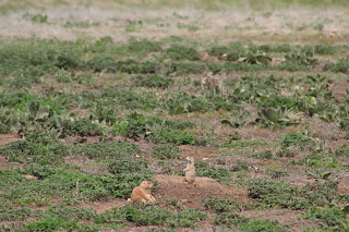
After the interesting tour and getting a glimpse of the box work that is EVERYWHERE in the cave, Amber and I had a nice picnic lunch at the park (enjoying the entire area completely to ourselves.  Then it was time for some prairie dog spotting.  Only this time, as we realized early on, the prairie dog towns at Wind Cave were filled with cute baby pups.  We easily spent an hour watch them and trying to get good pictures.


Eventually we loaded up and drove up north through the park and entered back into Custer State Park.  We took our time driving the Wildlife Loop Road, seeing plenty of bison, pronghorn antelope, and a few deer.  The rolling prairie and scattered forests of ponderosa pine is very beautiful in the spring.
We made a final stop near the main state park visitor center to watch a very well done film about the park that features Kevin Costner as the narrator.  Also nearby was the State Game Lodge.  They had two historical rooms set up available for viewing.  Presidents Calvin Coolidge and Dwight Eisenhower had stayed in them when they used to vacation in Custer State Park.
By that point it was getting late in the day so we headed down to Hot Springs to buy a few groceries and get checked into our motel room for the night.  Hot Springs would be a neat place to explore more of in the future.  They also have quite a few attractions (including an indoor water park/pool using the naturally warm springs in the area).  The name is misleading, however, since there are actually no "hot springs" in Hot Springs.  They are all warm springs (in the 80's).

Friday May 17, 2019
We woke up to booming thunder and lots of rain.  It didn't seem like it was going to let up, so we hastily packed up our car in an attempt to keep as dry as possible.  It was beginning to feel like the end of vacation with the absence of our nice weather and today was the day we began making our way back home, but not without some detours.

Our first stop was only 1 hour away, at Jewel Cave National Monument.
It was a great morning to be underground, but we did have to stand outside in the cold for a while.  I had done my research and Jewel Cave is very popular, and they don't offer many tours.  For this reason tours sell out very quickly.  In order to ensure we got a spot on the scenic tour, we were in the first group of people in line to buy tickets.

I didn't bring my camera into the cave on this tour.  But Jewel Cave was perhaps more fascinating to me than Wind Cave.  It is a barometric cave just like it's counterpart Wind Cave.  Currently, there are over 200 miles of mapped cave passage.  This currently makes it the 3rd longest cave in the world.  The NPS and cave researches have been doing quite a bit of scientific study and based on their measurements of air volume flowing out and they believe only about 5% of the total cave system has been explored.  5%!!!!  So 200 miles is only 5% of the cave.  Even more fascinating, is there is a strong belief based on what they have discovered that someday it will probably connect with Wind Cave National Park.

Jewel Cave is very special, in that it is covered, and I mean COVERED with calcite crystals growing on every wall, ceiling passage, and dome.  There are places where it has broken away from the limestone walls, revealing your typical rock cave passage.  Also very noteable is a giant piece of bacon that's been growing it's way down a wall.  Here is a link from the USGS for a photo of it.
Cave Bacon

After our cave tour ended our next stop was into Wyoming to try and visit Devil's Tower National Monument.  We realized we were starting to get behind on our plans, but it's vacation.  Amber and I were staying with friends, Chuck & Kathy, in Forsyth, MT.
We arrived around 2:00 in the afternoon, and it was a torrential downpour.  We scurried into the Visitor Center to buy some post cards, get our stamp, and read up on the history.  By the time we were done and had eaten a quick lunch the rain had turned more to a cold drizzle.  But since it might be years before we return to Devil's Tower, we were determined to follow through with our plans.  We put on our rain gear and set out on the 1.3 mile Tower Trail that lets you hike around the base of the rock monolith.
The weather was very moody, but it added a different touch to the scenery.
When we finally left Devil's Tower, we realized we were going to miss our dinner plans with Chuck & Kathy, but they were willing to have food ready to heat up for us when we arrived.  They are the parents of my former roomate in Spokane, Alex.  Amber and I got to spend time with them while we were dating, and they would be in town visiting.  Their love of good conversation, and simplicity has led us to become good friends and we enjoy our time with them.

When we finally arrived around 7pm that night in Forsyth, MT, we were spoiled.  We were given plates filled with fried chicken, mashed potatoes & gravy, and veggies.  We spent the evening catching up, telling stories, and just enjoying company until we retired for the night.

Friday, May 24, 2019

Great Plains Road Trip Part 4

Wednesday May 15, 2019
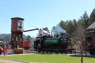
Amber and I were up somewhat early because we had a 1 hour drive down to Hill City, from our Airbnb rental in Lead.  Months in advance we had reserved a couple tickets on the 1880 Train that runs between Hill City and Keystone.  The line was originally used for mining in the Black Hills, but now only a small portion is preserved and it functions for tourism.  For more history you can visit their website 1880 Train History

The 1880 Train has numerous locomotives they run depending on time of year and different events, as well as rail cars.  Our locomotive was #104
We had some time to buy some post cards (of course!) and Amber bought a shirt before we boarded up and were on our way.
As we left Hill City the rail line immediately went up.  It's a 4% grade to the top of what they call "Tin Mill Hill".  Our little locomotive slowly chugged it's way up and the deafening sounds of steam power reverberated off the granite walls surrounding the track at times.  Along the way an interpreter tried to give us some history of the train, railroad, and the surrounding area.  Sometimes it was hard to hear, but I did remember learning that our particular locomotive now runs on recycled motor oil as it's fuel source to produce steam.

When we arrived in Keystone an hour later everyone had to disembark while they switched the locomotive around and refilled it with water.

Amber and I were in a different rail car, on the opposite side, for the return trip back to Hill City.  It gave us a chance to see some more of the scenery.

At one point we were told by our interpreter that the train passes through "Echo Valley" which is on the backside of Mt. Rushmore.  If you have attentive ears while at Mt. Rushmore you may be able to hear the train's whistle carry on the wind.  I made a mental note to remember that as Mt. Rushmore was our next destination when we arrived back in Hill City.

I guess everyone has to visit Mt. Rushmore at least once, and pay for parking in a giant parking garage.  We came all the way to South Dakota, so we might as well see it.  I was thankful it didn't appear to be too crowded and stressful yet, for early May.
We hiked along the Presidential Trail, and visited the museum exhibits and visitor facilities.  And I did hear the train whistle!  It was neat to learn some more history, but I don't think I will plan on going back until I take my own kids there someday.

For the rest of the day, we made our first venture into Custer State Park, by driving the Needles Highway.  However, we had barely entered the park when out my window I spotted what I thought to be a very beautiful lake.  We pulled off the road and decided to hike around the entire lake.  Indeed, it is a very stunning place named Sylvan Lake.  Pictures can't do it justice.


It was a glorious afternoon for a hike around the lake, and afterwards we found a small store that had a freezer full of ice cream bars.  It couldn't have worked out better to indulge (and of course, find more post cards)

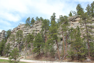
When we continued driving the Needles Highway, I tried to compare it to something else I knew.  But quickly I realized there is nothing else on earth (at least that I am aware of) that can compare to the tall granite spires of the Central Black Hills.  They are so unique and exquisite, and just declare the majesty of our God.  And on top of that, the fact that God would gift a man named Peter Norbeck with the architectural vision and imagination to create the very highway we were driving on... Wow!  I would say driving the Needles Highway is one of those things a person should do in their lifetime.


We soon found ourselves back in the lower elevations of the Black Hills and we made our way back to Lead for our 2nd night in our interesting accommodations.  The day wouldn't be complete, however, without one more twist.

As we were pulling onto the narrow road leading to our rental, we looked straight ahead at a very dark cloud in the distance, but still over the town.  Right before our eyes a bolt of lightning arced downwards followed a half second later with a tremendous clap of thunder.  A minute later we entered the house and discovered we were without electricity due to that lightning strike.  We had been depending on that electricity to cook dinner, do some more laundry, and clean up with a hot shower after a long day.  So what did we do?

Well settle in for the evening writing post cards and eating Chex Mix and Poptarts while we still had some sunlight.  Thankfully though, about 2 hours later power was restored and we were able to enjoy a late, but hot dinner before calling it a night. :)

Wednesday, May 22, 2019

Great Plains Road Trip Part 3

Tuesday May 14, 2019

The next morning I was up bright and early from the blazing sun streaming through the windows, despite having the blinds drawn.  The spring South Dakota sun was just adamant about making sure I was up and ready to get moving.  After eating breakfast, Amber and I were at the Notch Trail Trailhead before 8am.
Very quickly the trail leads you into the narrow, twisted canyons of the Badlands and any sign of civilization you saw is gone.  It's a maze and jumble of colored rock/clay layers, impressive spires, and the occasional hard washout surface from a bygone thunderstorm.  Yellow wild flowers grew in large quantities and provided a fresh look on the Badlands formations.
Soon we reached the famed wooden ladder that provides access to the upper reaches of the Badlands Wall.  To continue on the trail you must negotiate it.

From that point forward it was just a stroll through the upper reaches of the formations until we arrived at "The Notch", the trail's namesake.  It provides a stunning view of the Badlands and White River Valley to the south.

Once making our way back to the trailhead, the rest of our time in the Badlands was spent driving the park road, hiking the Cliff Shelf Nature Trail, walking the Fossil Exhibit Trail, and taking in all the sites, sounds, and fresh thunderstorm smells Badlands National Park offered that day.

We did get a real treat on our drive, later that day, however.  We came around a corner and on a nearby ridge was a group of Bighorn sheep and some babies.

When we reached the end of the paved road through the park, we took a detour down Sage Creek Rim Road for an hour or so.  It was dirt, but relatively smooth.  We saw some more neat overlooks and made it to Robert's Prairie Dog Town.  It was also down this road where we finally saw some bison that we heard existed in the park.

When we bid farewell to Badlands, our next stop was going to be the Black Hills.  It wasn't too far to drive.  We refueled and stocked up in Spearfish before deciding to spend the rest of our day exploring the Spearfish Canyon Scenic Byway.  It was our first taste of the Black Hills, and it gave us some spectacular scenery.  Not too far into the drive we happened upon Bridal Veil Falls.  It was right by the highway so we didn't have to hike anywhere.
A little farther on we came to trail head parking for Roughlock Falls.  You can drive up to it, but Amber and I were up for a hike so we elected to enjoy the warm afternoon.  We followed the creek up a canyon until we reached the falls.
Spearfish Falls is nearby too, but we didn't have time to complete the hike to the Lower Falls lookout.  I guess it will be there waiting for us next time.  We had to get a move on to Lead, SD, where we were renting an Airbnb for the night.

Finding our rental in Lead was quite an adventure.  If you've never been to Lead, DON'T GO!  The streets are confusing, illogically laid out, and most of the side streets are very narrow and steep.  I'm not sure how year round residents fare in winter.  Even studded tires aren't going to help you out in Lead.  When we did finally reach out place, I was in for another surprise.  Like a typical man I didn't really pay much attention to the item on the listing that said "Pet Friendly".  I just saw the great price tag and booked it.

As soon as we stepped inside my allergies were on full alert.  Dog hair was EVERYWHERE.  Thankfully we discovered a small washer/dryer combo in the unit and were able to rewash the bed sheets which helped a little.  But in the end we made the best of our situation and I threw some brats on the electric grill as a thunderstorm rolled through.

After a satisfying meal, popping some Allegra, Amber and I settled in for the night by an electric heater, Food Network, and writing post cards to send out in the morning.

Tuesday, May 21, 2019

Great Plains Road Trip Part 2

Monday May 13, 2019
Right at the stroke of midnight Amber and I were rudely awakened by bright flashes and the booming echo of thunder.  It was quite a surprise, as the weather had been perfect just a few hours before.  We lay in our tent watching the lightening, listening as the thunder got closer, and finally some high wind and rain arrived.  Thankfully, however, the main brunt of the storm missed us.

After the rest of the night being pretty sleepless, we arose and made breakfast while packing up our wet tent.  When we were all loaded up we headed south to reach Badlands National Park by the end of the day.  Along the way we stopped for groceries in Spearfish, SD, and made a quick stop at Walldrug, in Wall, SD.

The first NPS park site we came to as we neared the Badlands, was the Minuteman Missile National Historic Site.  We viewed a replica of a missile in it's underground bunker (at a poorly signed interstate exit) and then later toured the visitor center.  Sadly, we didn't have enough time to schedule a tour of the command center a few miles nearby.


As we neared the entrance to Badlands National Park, Amber and I finally found a little "Tourist Trap" right outside the park entrance.  We had seen it in this video I have linked below.  Skip to about 4:00 in the video to see it.  It's a place where they let you feet a group of prairie dogs some peanuts.  You pay $1 for a small bag.


It was a pretty fun experience to do.  The prairie dogs were very hungry for us, and sadly we ran out of peanuts very quickly.

After our little dose of cuteness, we finally entered Badlands National Park.  We met a couple on their honeymoon, and we each offered to take pictures for each other.
We had a little bit of time, so we drove down to the Visitor Center to tour it before checking into our cabin at Cedar Pass Lodge.  Amber and I like to stay at some of the National Park Lodges, and this was one we had set aside some money to stay a night.  The cabins had recently been remodeled, and they were very nice.  We had a back porch with a front row seat of the Badlands Wall before us.
The gal working at the check in desk told us the Lodge's dining room would be closing at 6:30pm, so we hurriedly cleaned up (and I lay my camping gear out to dry) in order to make it to dinner.  We were both thinking on the same page with burgers & onion rings.

After dinner we still had a couple hours of daylight left, so we decided to drive back up Cedar Pass and do some short hikes.  We ended up hiking the Window and Door Trails.  The evening light was perfect conditions for viewing the Badlands, and rendered some spectacular views on our evening adventure.


As the sun set, Amber and I made it back to our cabin to watch the sunlight fade away over the Badlands Wall.  We hung around outside a bit longer before settling in to write post cards, journal, and rest up for the next day.