Tuesday, October 5, 2021

Utah Road Trip Part 4

 First thing in the morning Emily and I made breakfast: and then we zipped off to Priority #1 for the day.  Go to the Gifford house first thing that morning when they opened, to load up on pie.  At this time of day they were fully stocked so Emily and I both got strawberry-rhubarb pie and I grabbed a cinnamon roll to split with Amber.

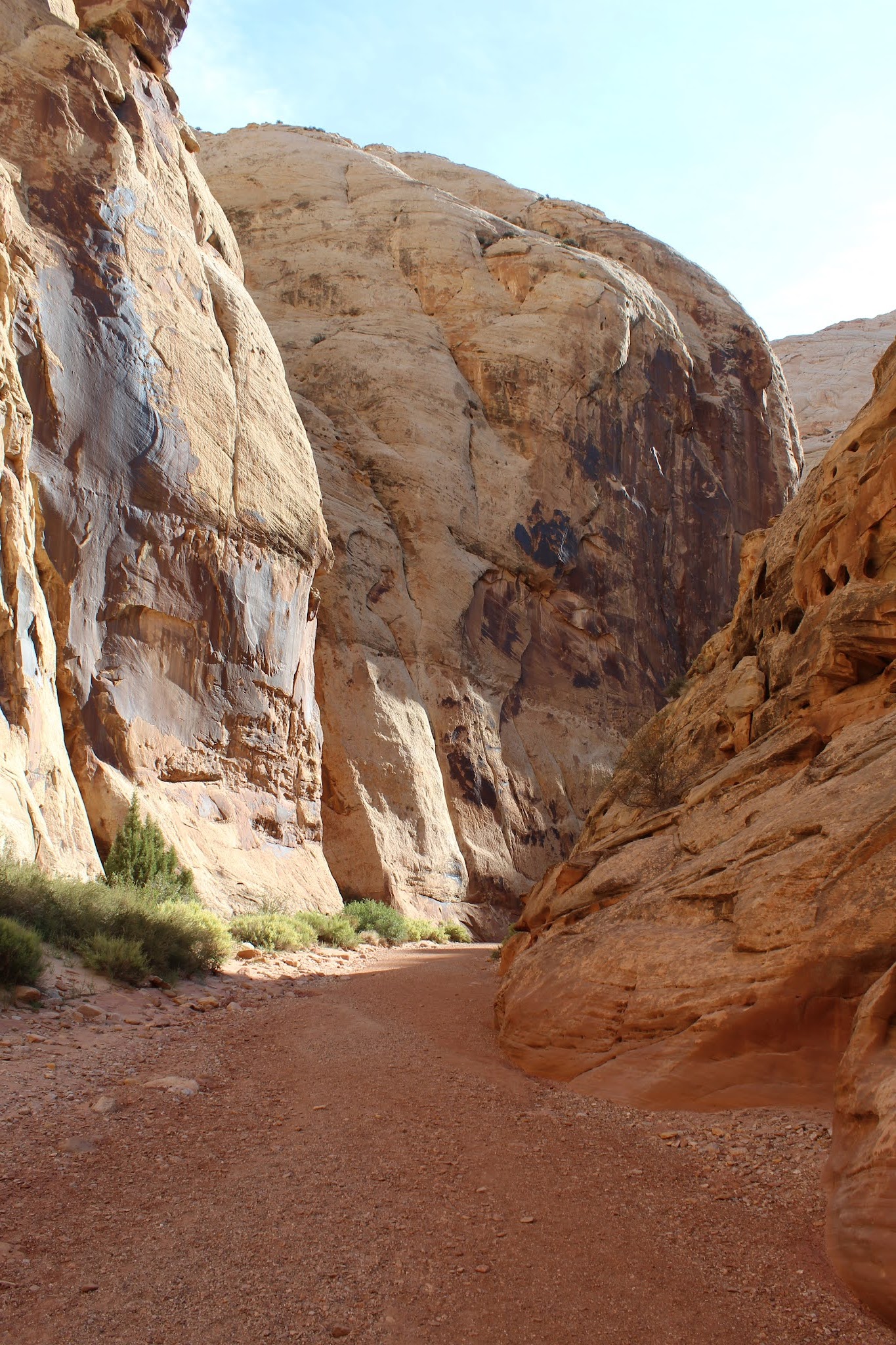
Then it was time for the second priority: Grand Wash Trail.  It is pretty similar to the Capitol Gorge Trail, except it has some sections of canyon that are narrower.


After we finished up our hike we headed back to camp to have some lunch.  Then while Amber & Addie rested, Emily and I embarked on a more difficult hike that we had been wanting to do.  We hiked the Cohab Canyon Trail, and went to both overlooks.  Cohab Canyon had a reputation for being a hiding place for the polygamists when federal agents came to the area to enforce marriage laws.  Cohab is a "Hanging Canyon", or a canyon above another canyon.  It's a steep climb to get to the mouth, but definitely worth it.


You eventually hike out of Cohab Canyon and then there are a couple spur trails to take you to different overlooks of the Fremont River/Fruita area.  The views were incredible and even made me dizzy as I peered over the edge of the sandstone cliffs.


Emily and I hiked back down to our camp and visited with Matt, Amy, and their kids as they had stopped by to say hi on their road trip.  After they took off we loaded up in the car to check out a couple more sites before we prepared to end our time at the park.  We checked out the historic Fruita school that the Park Service has preserved, as well as some petroglyphs from the Fremont people, before white settlers arrived in the area.


Our final stop was an area called The Goosenecks.  It's jaw dropping to see and the pictures don't do it justice.  Sulphur Creek is far below and the canyon seems to come out of nowhere.


When we had finished up exploring the area a bit more it was time to make dinner and then settle in for the evening.  It had been a full day of adventures and it was going to be sad to begin the trip home in the morning.  Capitol Reef gave us one more surprise, however.  Beginning in early evening we began getting some thunderstorms in the area.  The weather was very moody for a while, but at one point the sun poked out from behind the clouds and illuminated the red rocks and one of the barns.  I ran over and took what is probably one of my favorite pictures of the trip.


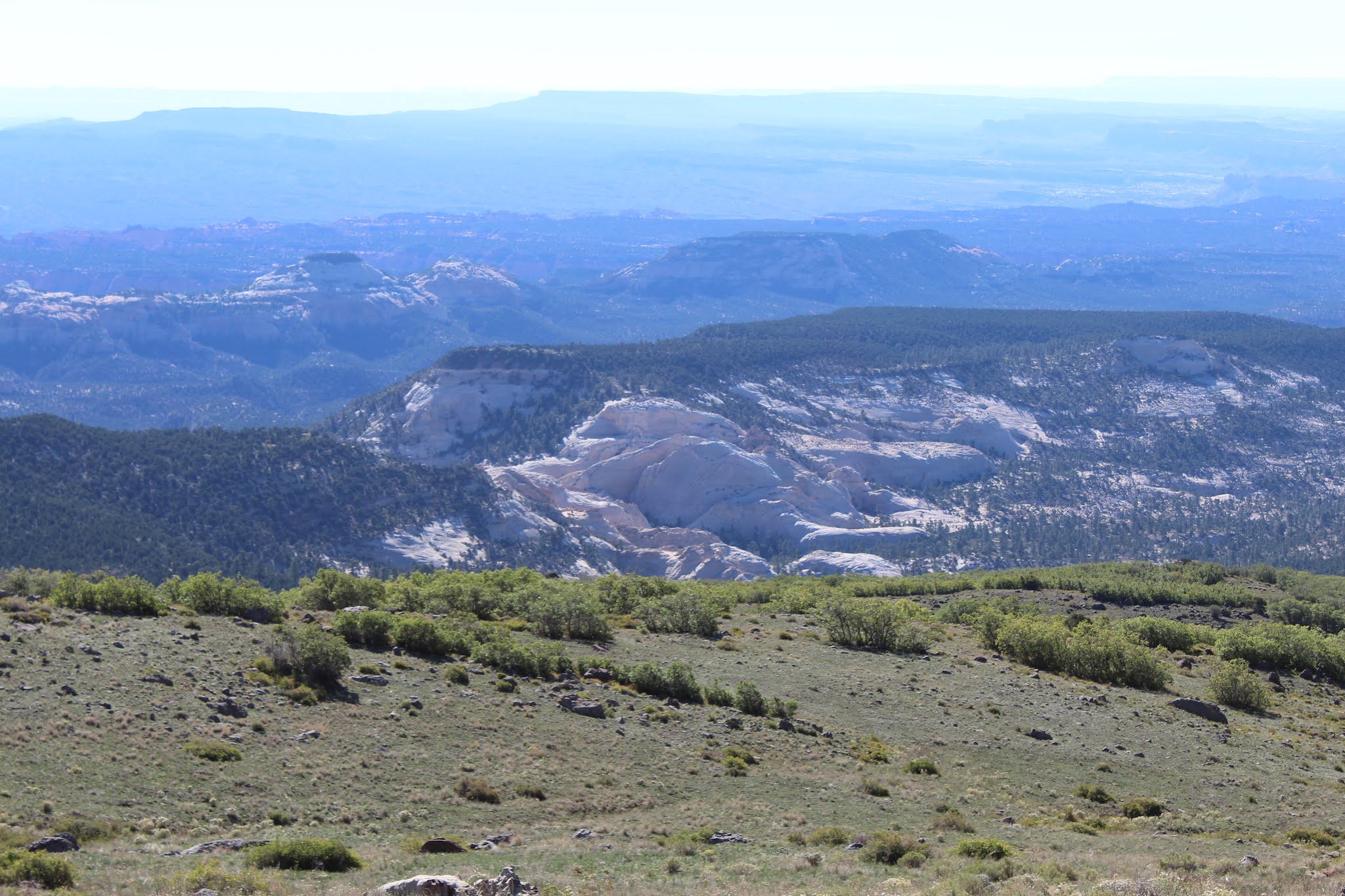
In the morning we were packed up and on the road before 8am.  It was sad to leave Capitol Reef- It moved into my favorite National Park that I have visited so far, barely edging out Theodore Roosevelt NP in North Dakota.  The next couple days would be mostly driving, but we had one more stop we wanted to squeeze in on our way back home.


When we finally arrived in North Utah in mid-afternoon, we only had a couple hours to explore this park.  That meant no auto tour or hiking for us on this visit, so we focused mostly on the Visitor Center and seeing one of the steam engine demonstrations.

Golden Spike National Historical Park commemorates the meeting of the Union Pacific and Central Pacific Railroads completing the nation's first transcontinental railroad on May 10, 1869.  I won't drone on about the history: You can read an excellent book by Stephen Ambrose called "Nothing Like It In The World" that gives a great in depth analysis of the railroad from pre-planning to completion.  But it is worth noting that in this desolate area of Northern Utah both railroads were continuing to build grade and had even passed each other because no official meeting point had been set.  But Congress finally determined the meeting point to be Promontory Summit.  Thus the ceremonial driving of the golden spike was planned, and the Central Pacific's locomotive named "Jupiter" and the Union Pacific's "No. 119" met in the middle.


The Park Service operates replicas of both locomotives and during the summer they do demonstrations for the public.  We were able to watch the No. 119 do a demonstration run late in the afternoon.


I would have loved to have spent more time exploring the area, but we just didn't have the time as we still needed to get checked into our lodging in Logan for the night and buy groceries.  But Golden Spike does also offer hiking and self guided interpretive auto tours along the original railroad grades.  It was a great end to a very fun and memorable trip exploring parts of Utah for the first time.  It will be exciting to come back someday and explore more of Utah, but also visit Capitol Reef again.


And.... as a bonus.... here is a photo of the famous Preston High School, in Preston, ID.  Amber and I realized the next morning that it wouldn't take any more time to leave Logan, UT, and head back a different way through Preston, ID.  Every good Idahoan knows that Preston is the location for the unofficial Idaho State movie, Napoleon Dynamite.  We had to swing by the school and see those famous steps where Napoleon, Pedro, and Deb all hung out... 😁


Sunday, October 3, 2021

Utah Road Trip Part 3


Driving into Capitol Reef National Park was an incredible experience.  The towering red rock cliffs tower above you, and transport you into a new world.  We admired the scenery as we drove into the Park and got set up at our campsite we had for two nights in the Fruita Campground.

Capitol Reef is a place full of history, interesting geology, and stunning surprises around every rock.  The area is dominated by the 100 mile long geological feature called the Waterpocket Fold.  This incredible formation is a stretch of rock layers in the Earth's crust that was uplifted, folded, and then subjected to massive water erosion that scoured the terrain.  Evolutionary geologists (and the US Park Service) will try to tell you it took millions upon millions of years for the sediment layers to be deposited.  The Park Service even tries to tell visitors that the rock layers folded but were not broken.  When was the last time you saw a sedimentary rock bend and not be broken?  How about 100 miles of hundreds of rock layers?  It certainly takes more faith to believe that wild story than that of Genesis Flood account.  Massive sediment deposition is all across the American Southwest.  The mountains being raised out of the flood waters caused the still soft layers to bend and massive amounts of water sheeting off the continent scoured the landscape clean.

Like a lot of places in Utah, Capitol Reef was first settled by Mormon pioneers, in the 1880s.  The Fruita District, as it is called now, was the main area of settlement.  The settlers planted orchards, gardens, raised livestock, and carved a simple yet satisfying existence out of the desert oasis along the Fremont River.

We set up our camp in Fruita and then went to go check out one of the apple orchards first.  We were worried most of the apples would be picked already, but that worry was misplaced.  There were plenty to go around.  

While Emily, Amber, and I filled bags Addie had fun scrounging apples from the ground.  


After finishing up loading up on apples we still had some time before evening, so we decided to drive the scenic road through the Northern part of the park.


When we got to the end of the pavement we decided to drive down the Capitol Gorge Road and see if we could find parking.  After the seemingly long drive and the beautiful scenery we reached the trailhead and did get lucky with a parking spot.

Capitol Gorge used to be the only easily traveled path through the Waterpocket Fold, until the 1860s when UT route 24 was constructed.  Mormon pioneers used this route heavily to travel through the area, and plenty of them left lots of evidence on the canyon walls.  You can also still see metal poles hammered into the canyon walls that were used to hold telephone wires in the early 20th century.


By the time we hiked back out of Capitol Gorge, we were hungry and tired.  We headed back to camp and made a taco dinner.  But the real treat was our pie from the Gifford House.  We all ended up getting the last mixed berry pies that they were selling.  We enjoyed the treat and then settled in for the evening to prepare for the next day which would be our full day at Capitol Reef.


(Post Pie Selfie)

Wednesday, September 29, 2021

Utah Road Trip Part 2

 After packing up camp in the cold, we set out for a leisurely day of driving part of Utah Scenic Route 12.  We only had about 60 miles to go for the day.  After passing through Tropic and leaving Bryce Canyon behind, you quickly begin to descend and you are soon surrounded by "lower" rock layers.  I found a good turnout to get photos to help visualize how the Grand Staircase is situated, and slopes downward as you get closer to the Grand Canyon in Arizona.  The red layers you see in the upper right of this photo is the same layers that Bryce Canyon sits in.

This particular area with the grey mudstone/clay has become famous for holding lots and lots of fossils.  Sea creatures and dinosaurs have all been found in massive burial sites in these very cliffs.  More than likely this area was a dumping ground during the flood for the massive amounts of sediment laden waters carrying the dead/dying animals.  When the land was raised upward out of the water, the rush of liquid flowing off the continents exposed and scoured out this area of the country.

We made it to Escalante and had a few hours to kill before we could check into our cabin, so we decided to check out two areas.  The first was the Hole-In-The-Rock Escalante Heritage Center right outside town.  This place tells the fascinating history of some of Utah's early Mormon pioneers.  The remote, rugged, and extremely hazardous terrain presented many challenges back in the day.  A group of 250 men, women, and children left the settlement of Escalante with the goal of blazing a trail to the far Southeast corner of Utah, near the San Juan River.  They blazed a wagon trail through the area along which the now named "Hole in the Rock Road" mostly follows.  The "Hole" part comes in when the group reached the Colorado River 1,800 feet below them.  Scouting revealed only one natural break in the canyon anywhere in the area.  The catch was it wasn't quite large enough for the wagons to pass through.  It took the settlers 6 long weeks of back-breaking work to blast and chisel the gap wide enough for them to pass through.  When it was all said and done, they basically slid their wagons down in controlled falls using ropes and friction to navigate the gap.

After our visit to the Heritage Center we went back to the West side of Escalante and visited Escalante Petrified Forest State Park.

Looking back now, I can't say I was particularly impressed with this park.  Despite their public hours saying they were open, there were no staff around to open the visitor center or provide information and guides on the hiking opportunities.  No reasons were made available on why this happened.  We ended up hiking the petrified forest loop which is pretty steep to get up onto a plateau.  You would think with a name like "Petrified Forest" there would be lots of trees, but that wasn't the case.  In fact, until the very end of the loop trail you hardly see any.  Certainly some of the specimens are impressive, but I probably wouldn't do the hike again.  I would go visit the National Park site in Arizona (which I haven't been to yet).


By this point we were hot, tired, and ready for showers and clean clothes.  We got checked into our small cabin in Escalante and spent the rest of the afternoon/evening getting clean, doing laundry, and gorging ourselves on hamburgers & milkshakes at the local Nemo's Drive Thru.

In the morning we whipped up a filling pancake breakfast and then headed out to finish our drive on HWY 12.  The route took us through more of the Northern tip of Grand Staircase-Escalante N.M, ultimately sending us up North to Capitol Reef.

Words really can't describe how beautiful and rugged the scenery became once we left Escalante.  It's almost like being on another planet and it's crazy to me how a worldwide flood meant to judge sin upon the world can still bring beauty to our surroundings.  It is literally nothing but rock and they built a highway through this area.


After a ways you drop down into the Escalante River & Calf Creek Canyon area.  I didn't get any photos from inside the canyons as you drive along, but take my word that it is very scenic and there are a multitude of hiking opportunities in this area.  We didn't do any because they are a bit longer distance and we had decided we wanted to spend most of our time in Capitol Reef.


After leaving the Calf Creek area you eventually climb upward and traverse what is known as "The Hogsback".  You drive on a small sliver of narrow ground atop a mesa, with steep drops on either side of the road.  If you don't like heights this would terrify you, but I found this part of the drive very pleasant and beautiful.  Here is a link if anyone is interested in this section of HWY 12  https://scenicusa.net/021110.html

The final part of the drive is after you leave Boulder, UT.  You gain some serious altitude and there are opportunities to see across Utah and even at times you get distant glimpses of the Waterpocket Fold in Capitol Reef (More on that later).


Then on the descent into Torrey (The gateway town to Capitol Reef) you suddenly begin seeing the stunning red rock cliffs jutting out of the landscape.  The contrast to the pine forest you leave behind is simply stunning.  As we got closer and closer they seemed to get taller as they drew us into what would become my favorite part of the entire trip: Capitol Reef County.

Monday, September 27, 2021

Utah Road Trip Part 1

 It was our last vacation before baby #2 arrives in March.  Neither Amber or I had ever really explored anything in Utah, so we decided to pick a couple National Parks to visit.  Partly due to not wanting to face the insane crowds, and more of the things on my bucket list not being good items for a toddler, we decided not to visit Zion.  We settled on Bryce Canyon and Capitol Reef National Parks for this visit, with a quick visit to a small portion of Grand Staircase-Escalante National Monument in between.

After getting off work late on Friday evening we booked it 2 hours south and stayed the night in a "Jail house turned apartment".  We wanted to be 2 hours closer to the Salt Lake City area because I wanted to visit the Idaho Potato Museum in Blackfoot, ID.  Being an Idahoan, it was my duty to visit and learn about all things potato.

Addie enjoyed a kids area where she was able to play with hundreds of Mr. Potato Heads.  She also took a liking to the potato family that sings an annoying song about.... you guessed it.... Potatoes!

After finishing up we didn't do much else in the way of excitement except the long drive to Salt Lake City where we met up with my sister Emily at an Airbnb for the night. We prepped food and planned to get down to Bryce Canyon the next day.

The following morning we again didn't do much except drive the first half of the day.  If you ever drive I-15 south through Utah you know there's not much to see.  But when we finally turned onto Scenic HWY 12 it finally got interesting.

We headed straight for our campsite we had reserved for 2 nights, at the Sunset Campground.  After eating lunch, visiting with Uncle Brett & Aunt Laurie (who were staying in the area a couple nights), and taking care of things at the park visitor center, we had a bit of time left to finally get our first views of the Bryce Amphitheater area and the "Hoodoos" at Sunrise Point.


Bryce Canyon sits at the upper North end of what is called the Grand Staircase.  It's a massive uplifted plateau with sedimentary rock layers stretching from Southern Utah down to the Grand Canyon in Arizona.  Most likely during the uplift of the continents and mountains during Noah's Flood, most of the sediment was removed from this region.  It resulted in places like the Grand Canyon, Zion, and Bryce Canyon being exposed.  In the short term, most scientists believe mechanical weathering has been responsible for forming the unique hoodoos that Bryce Canyon is famous for.

Bryce Canyon got it's name from a Mormon Pioneer couple named Ebenezer & Mary Bryce.  The family was instrumental in making the Bryce Amphitheater and canyons more accessible.  It became known as Bryce's Canyon, with the "s" eventually being dropped.  In 1923 the area was designated a National Monument, and in 1928 it was changed to National Park.

After poking around Sunrise Point we headed back to our camp to relax, make dinner, and we planned to hike with Uncle Brett & Aunt Laurie in the morning.  We would meet up with them and hike down among the hoodoos on the Queen's Garden Trail, and hike out on part of the Navajo Trail.

The next morning brought cold temperatures and we hadn't slept very well.  But after breakfast we headed off to Sunrise Point to meet our relatives to do our hike.  The descent down to Queen's Garden felt unreal, as this was our first time every being face to face with the hoodoos.


The Queen's Garden is an area of very impressive formations, one of them looking like Queen Victoria.

We took a break here, and then continued onto the Navajo Trail.  We elected to not do the entire Navajo Loop, so we ended up doing the part that took us by Twin Bridges and Thor's Hammer.  The views on this stretch of the trail were even more impressive, and the steep climb out back up to the rim was constantly gifting better views.

(Twin Bridges)


(Thor's Hammer)
After finishing up our hike we headed back to camp and had lunch.  Then Amber and Addie hung out at camp while Emily and I decided to go on another hike.  We headed out to the parking for Bryce Point and hiked about 1.5-2 miles down the Hat Shop Trail.  The hikers were few and far between and we had the trail mostly to ourselves.  While not as grand as the more famous trails elsewhere in the park, the solitude was a breathe of fresh air.
Then we began our hike up out of the "canyon" for the second time that day and we realized how tired we were.  When we arrived back at camp we were content to rest for a couple hours before heading out again; this time to drive the scenic park road all the way to Rainbow Point.

Rainbow Point is the highest point in the park, reaching 9,115ft above sea level.  It gives you stunning views to the North of the eroded formations that present a problem for people who believe the region was formed over the course of millions of years.  On the top sits hard volcanic rock while the soft "pink cliff" clay layers show relatively little erosion in comparison.

While at Rainbow Point we hiked the Bristlecone Loop Trail and that gave us enough mileage in the park to get our "Hike the Hoodoos" award at the visitor center later.


After finishing up at Rainbow Point we drove back to camp, with the only spot we stopped at on the way back was Natural Bridge.  We were too tired to do anything else besides head back to camp to make dinner, visit with our family, and bundle up for another cold night.

The next morning brought 30 degrees as we packed up camp, but we had stayed warm and had thankfully slept well.  We headed out of the park on our way to Escalante, UT where we would have a chance to sleep in a warm cabin, get showers, do some laundry, and enjoy some more beautifully rugged scenery left behind from Noah's Flood.