Saturday, June 12, 2021

Idaho Road Trip Part 4

 In the morning we all packed up camp and said goodbye to my parents.  They were heading back to their home, and we were heading over to the far reaches of Eastern Idaho.  Of course, we had to stop in Idaho Falls and get some late breakfast/early lunch at Chic Fil A, before continuing on our way to Ashton, ID.  Ashton is the beginning of the Mesa Falls Scenic Byway.  We only had plans to go far enough to just see both the Lower & Upper Falls.  These had been on my bucket list for years and it was exciting to finally get to see them.
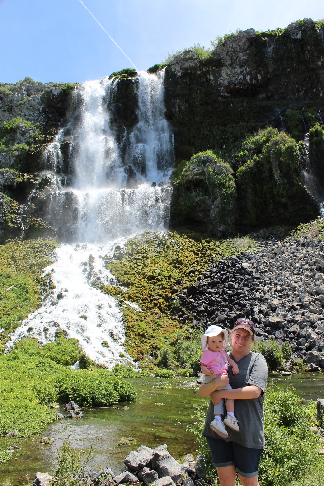
(Lower Mesa Falls)

Mesa Falls is on the Henry's Fork of the Snake River.  The Upper Falls is about 114 feet tall.

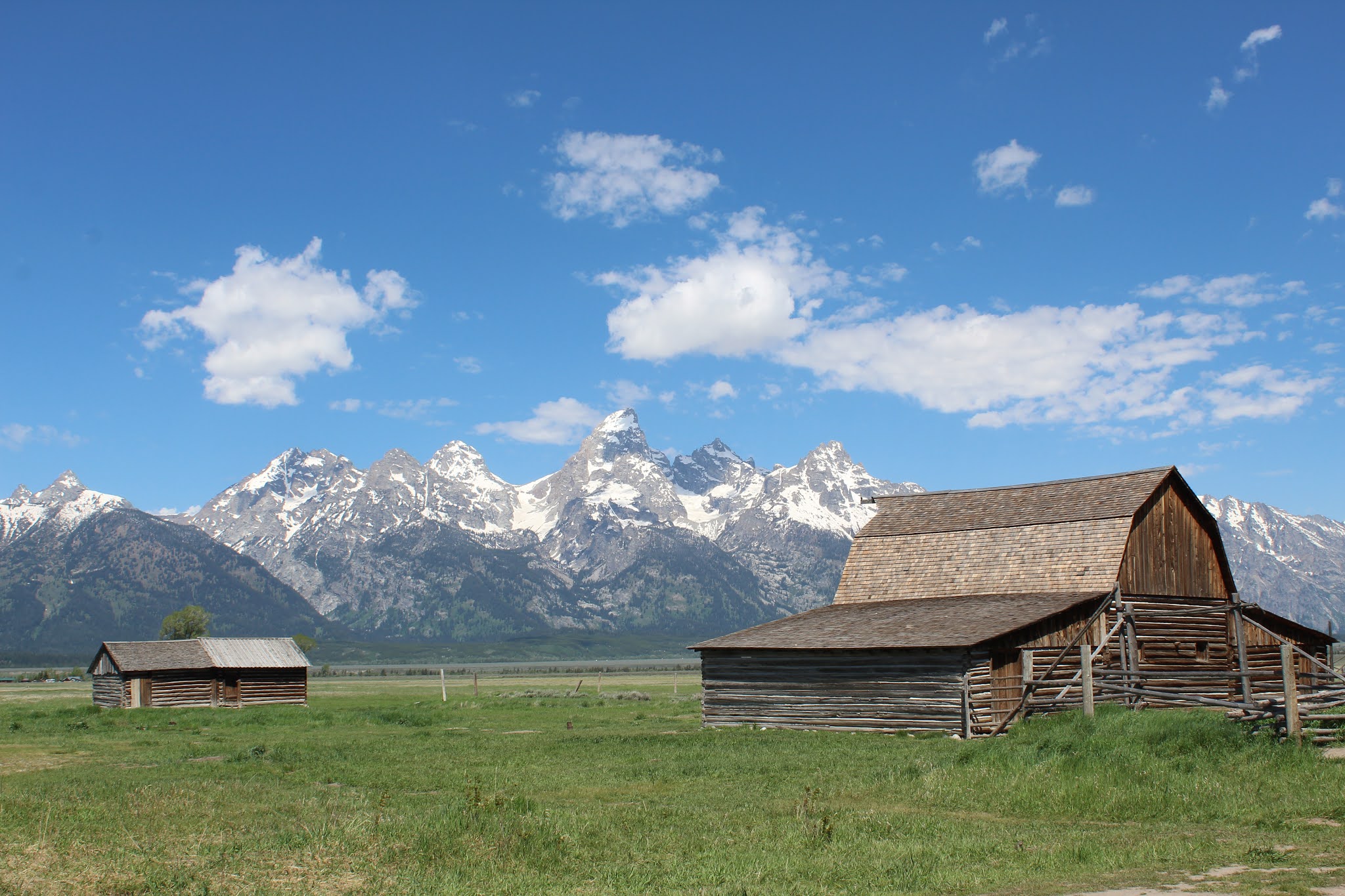
After finishing up at Mesa Falls, our plan was to cut across the mountains on the Ashton-Flagg Ranch Road.  It's a scenic backroad that spits you out on the other side of the mountains between Yellowstone and Grand Teton National Parks.  From there we would have driven through a lot of Grand Teton before arriving at our campsite at Jenny Lake.  We soon discovered, however, that our plan wasn't going to work out.  The local sheriff had closed the road about 20 miles in, but no signs or alerts had been posted.  So we were forced to turn around, backtrack, and then drive South.  It was a very pretty drive, but the traffic was horrible.  The culmination was Teton Pass.  I didn't realize how bad that pass would be at a 10% grade and thousands of cars, trucks, and RVs.  

We  made it into Jackson and then had to wait while we did some laundry at an overpriced laundromat ($9.00 for one wash load!).  When we finally made it into our campsite at Jenny Lake it was almost 5:00.  But we were all happy to finally be in a quiet and peaceful place.  We had no plans to do anything the rest of the day except set up camp and make dinner.  Addie was content to just wander around the campsite and try and fill our tent with rocks.


During the night Amber and I didn't sleep well.  We were tired from our long trip so far, still getting over our colds, I had a really bad sunburn, and we were ready to sleep in our own beds.  We decided during the night that we weren't going to stay our second night.  We would instead do some exploring the next day until about noon and then head home to Montana.

In the morning we had breakfast and packed up camp.  We spent some time exploring the area around Jenny Lake until the Visitor Center opened and we could get our NPS Passport Stamp.


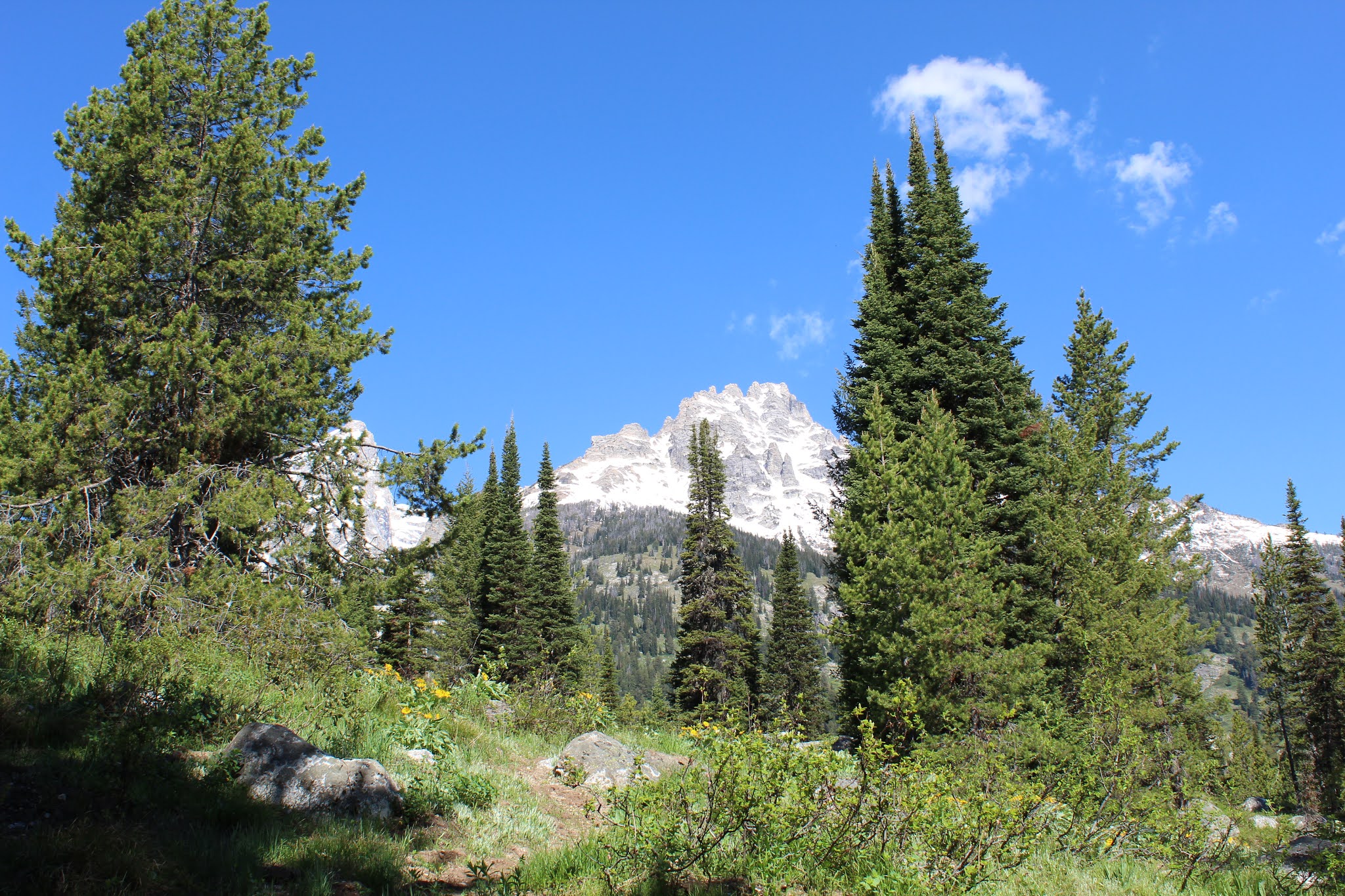
After leaving Jenny Lake we went to the Lupine Meadows Trailhead and we hiked up the trail for about 1 mile.


Once we finished up our hike, we still had a little bit of time to explore.  We decided to go visit the Chapel of the Transfiguration.  It was a beautiful location for a church, and services are still held in it during the summer.  It was built to give settlers a house of worship so they didn't have to make the arduous journey into Jackson.


Our final stop was the Mormon Row area of the Park.  It's farther out in the valley, and its an area with old Mormon homesteader buildings.  Some of the famous pictures of old barns in the Teton Valley are taken here.  We didn't do much besides taking some pictures, eating a quick lunch, and then hitting the road for the long drive home.  We were ready to sleep in our own beds and get some much needed rest.  Overall it was a good trip, but it certainly had its challenges.  It was our first long trip with Addie, and going forward we will definitely be applying the lessons we learned about traveling with a child.  It's just not the same as we are used to.  But we made fun memories and look forward to having more adventures together.


Friday, June 11, 2021

Idaho Road Trip Part 3


Thursday morning we were all up so we could load up the cars and make the almost 2 hour drive to Craters of the Moon National Monument.  The campground is only first come first serve, so we wanted to make sure and be able to claim a spot that would offer us a little bit of afternoon shade.

Craters of the Moon was my favorite place we visited on our journey, mainly due to the incredibly odd scenery.  Southern Idaho is full of igneous rock that was formed during the tectonic uplift surrounding Noah's Flood.  The Craters of the Moon lava field (and a couple others in Eastern Idaho) stick out in stark contrast to all the other landscape, however.  They were clearly formed after Noah's Flood, along what scientists call Idaho's "Great Rift Zone".  It's essentially a crack(s) in the Earth's crust and magma was allowed to come to the surface.  The difference compared to the Cascade volcanic range on the Pacific Northwest Coast, however, is that gases were not typically held back under enormous pressure.  The lava was typically free to flow across the landscape and thus did not result in large stratovolcano building.  Instead Craters of the Moon is filled with acres of lava, conduits, spatter cones, cinder cones, and lava tubes.

After setting up camp we were determined to take advantage of the day, even though it was very hot.  We only had one day to explore.  We decided to base our hiking and exploring off the short 7 mile loop road that winds through the Park.  There is plenty of longer hikes you can do (such as hiking to tree molds) but it just wasn't on our itinerary as we are adjusting to having a toddler with us.  So our first stop was Inferno Cone.  Amber, Adelaide, and I hiked up to the top.  The strong wind was a nice break from the heat that was made worse by the black lava rock and cinder.


The views from the top are pretty nice, and they give you a sense of just how large Great Rift area is.  While I'm not sure on the exact size of strictly the lava flows, the entire Monument & Preserve covers 750,000 square acres.  And in addition to being able to see that before you, also visible are multiple buttes farther out on the Eastern Idaho Snake River Plain.

Just a short jaunt from Inferno Cone is the Spatter Cone area.  The Park Service has a couple short trails leading into the cones and you are able to look down into the deep throat of these volcanic formations.  Most scientists believe spatter cones form when there is just enough gas trapped in the lava and it has the right viscosity to "spatter" out in mini eruptions.  Not as violent as a stratovolcano, but not just oozing out peacefully either.


Our next stop was to one of the cave areas.  We made the hike out to Indian Tunnel.  It's one of the easier lava caves you can explore, which has several skylights.  It was easier to explore this one with my parents and while I had a baby on my back.


By the time we finished up in the cave area it was getting into the late afternoon.  We decided to make one more quick stop at the Devil's Orchard area before we headed back to camp.  That evening we tried to stay cool, cook dinner, and celebrated Amber's birthday.  We struggled to fall asleep with the heat, but we eventually did, knowing we had a long day ahead of us in the morning.

Tuesday, June 8, 2021

Idaho Road Trip Part 2

 After a very restless night and little sleep we all had breakfast and then headed out for the day.  We only had 2 things on our list for the day.  Minidoka National Historic Site, and City of Rocks National Reserve.  The two different parks are totally different in their purpose and goals.


Minidoka National Historic Site preserves the location and remains of one of the Japanese internment camps from WWII.  On February 19, 1942 President Roosevelt signed Executive Order 9066 which instantly branded anyone in the country of Japanese ancestry, as criminals and a threat to the country.  Two-thirds of those incarcerated were American citizens.  The government kicked them from their homes, shuttered their businesses, and forced them to abandon their farms.  Most of them remained in these various prison camps on the West Coast for the duration of the war.

Those imprisoned at Minidoka did their best to build a sense of community by organizing churches, sports, swimming, and planting gardens.  They were crammed into tarpaper & wood shacks.  It was brutal cold in the winter, and scorching heat in the summer.  At its peak, Minidoka held 9,397 individuals in March of 1943, with a total of 13,000 persons imprisoned during the camp's operation.

This park site is still in the developing stages.  When we visited, the brand new Visitor Center wasn't open, so we were limited to a paper flyer of information.  However anyone can find information in books on the other camps scattered across the West.  They provide lots of detailed information on this black eye in American history.

After finishing up at Minidoka, we headed to the Southeast to visit City of Rocks National Reserve, near Almo, ID.


City of Rocks got its name due to the California trail passing through.  One of the emigrants, James F. Wilkins described it: "...women and children wandered off the enjoy the sights of the city.  We were...spellbound with the beauty and strangeness of it all..."  The used this area to rest and lighten their wagon loads.  Many of them left their signatures inscribed onto the rocks (many of which can be seen today).

Sadly, we didn't do much beyond driving the dirt road that traverses the park.  The granite rocks scattered around are absolutely stunning, and multiple trails and camping could be enjoyed.  I want to return someday and actually spend some time exploring the area.  On this trip, we were all so tired (and Amber and I were sick), and the weather was too hot to motivate us to do anything besides drive.

I have yet to read a Christian geologist's perspective on the City of Rocks, sadly, so I do not currently have any insight into their formation.  I'm sure it happened during the tectonic uplift at the end of Noah's Flood, however.

Needless to say, City of Rocks is a beautiful area in a gorgeous remote section of Idaho that deserves a lot more attention someday.  But for us, that was the end of our adventure as we headed back to Twin Falls to try and get some sleep, keep cool, and get ready for our much bigger adventures the next day at Craters of the Moon National Monument.

Monday, June 7, 2021

Idaho Road Trip Part 1

 It was finally long overdue for the Holcomb family to hit the road again, and do some exploring.  This was going to be our first big trip since Adelaide was born in March of 2020, and we weren't sure quite what to expect.

We left home on Friday morning and didn't have much in our plans expect stopping for lunch at Stanley Lake.  I had never seen the lake before, and the Sawtooth Mountains are my favorite peaks in the whole country.

We arrived at my parents house Friday evening and we enjoyed a few days spending time with them, visiting some of Amber's relatives, visiting some childhood friends & people from church, and spending a day in the Owyhee Mountains hunting for rocks (I didn't take any pictures during this time).

On Tuesday my parents joined us as we began our road trip across Idaho.  The plan was to visit a few places that I had never made it to, despite growing up in Idaho.  We followed HWY 78 that took us through some beautiful country, before arriving at our first series of destinations for the day.  I wanted to see some of what Thousand Springs State Park had to offer.  The park is composed of quite a few different areas spread out across an area of Southern Idaho.  I had visited Box Springs Canyon years ago, but I hoped to see a little bit more.

We started out with eating a picnic lunch at Malad Gorge, and then doing a quick walk across the foot bridge.


My parents decided they wanted to see the Ritter Island section of the park so we headed there next.  A lot of the old homestead buildings weren't open for touring at that time, but we were able to see one of the many (Hence the name "Thousand Springs) impressive springs spilling down into the Snake River Canyon.  The water is believed to originate to the North where multiple rivers disappear into the porous volcanic basalt.  It reappears an estimated 100 years later in all these springs to the South.


After spending some time at Ritter Island, we moved on to visit Hagerman Fossil Beds National Monument.  Sadly the Visitor Center in Hagerman, ID (where you can view the fossil remains of the Hagerman Horse) wasn't open.  But we were able to go out to the Monument land and hike along a section of the original Oregon Trail where you can still see the wagon ruts worn into the ground.  It was pretty neat to imagine the struggling West-bound pioneers treading the very ground in front of us over 160 years ago, and to see the evidence still preserved.


In regards to the National Monument's name sake, it's a bit tricky to weed out all the evolutionary speculation and get to the truth.  Starting in 1929 excavations began after a local rancher had showed fossils to a government geologist.  To date the fossil beds have produced 20 complete Hagerman Horse skeletons.  The banks where the fossils are found are an area of exposed sedimentary rock beds immediately above the Snake River.  Buried on top of these sediment layers is the expansive volcanic rock that is found all over Southern Idaho.  At least from a basic geologic perspective the area must have been a massive burial location during Noah's flood: Whether that was due to bodies accumulating in this one particular area as a result of a water blockage, or it was a false vestige of safety for the animals fleeing the rising flood waters, and they were then buried there.  Most likely Post-flood volcanism then buried the surrounding area, covering up a lot more of these sediment layers.

Hagerman Fossil Beds was our last stop for the day.  So we headed to Twin Falls where we had an Airbnb reserved for a couple nights.  We all tried to relax and get some sleep for the next day's adventures.