With our impending move to Pasco, Washington approaching very quickly, Amber and I wanted to get out and see some more of Montana before we had to bid farewell for a time. My parents had came up after my last day of my job in Kalispell. We spent the weekend relaxing and preparing to head out bright and early into Glacier N.P., Labor Day morning.
We got a parking spot at Logan Pass and did the hike to Hidden Lake Overlook with my parents. This was their first (and probably only time) at Logan Pass, so we wanted to make it special for them.
After we finished our hike we made our way into Two Medicine and snagged a campground as people were packing up, their 3 day weekend just about over. We set up camp and then relaxed in the campground, by the lake, and my parents paid for a boat tour on Two Medicine Lake. When that was over we returned to camp to make dinner, play some games, enjoy a campfire, and then finally head off to bed.
The next morning I woke up to the sound of splashing water. In my groggy state it sounded like water splashing onto the ground out of somebody's camper nearby. However the sound continued off and on for quite a while. Finally, when my parents were the first one to get up, I heard, "There's a moose out here!" I hastily put on my close and stepped outside the tent. Sure enough, right in the pond next to our campground was a female moose having breakfast in the cool morning fog. She had been making the noise all morning.
The moose attracted a lot of attention from other campers for the next hour, and we kept a close eye on her until she wandered off away from camp. Then we packed up camp and began the drive home, stopping briefly at the East Glacier Lodge & Goat Lick Overlook. We unloaded, and then Amber and I reloaded our car for the next leg of our journey through Southwest Montana.
Wednesday morning we weren't up as early, and we set off with my parents in two different cars. We traveled down the Seeley-Swan Highway. Our end goal for the day would be Missouri Headwaters State Park near Three Forks, MT, but we made a stop at Grant-Kohrs Ranch National Historic Site first, in Deer Lodge.
Johnny Grant had started the cattle ranch in the 1860's, being one of the first settlers in the Deer Lodge Valley. Later on Conrad Kohrs bought the ranch. The site tells the stories of the individuals, families, and the daily life of workers on the ranch. It gave good perspectives on what life on the Montana ranch was like. We wandered through buildings, exhibits, and got a tour of the ranch house.
By the end of the tour, everyone was getting hangry. So we found a dilapidated picnic table at a "city park" in Deer Lodge to eat at. Then after stocking up on some more groceries we continued on our way.
As we neared Butte, MT, we saw a pretty massive fire burning in the mountains. When we crossed the Continental Divide we got some glimpses of how large it seemed to be. The high winds and dry conditions had probably just recently started the fire.
Early in the evening we finally reached Missouri Headwaters State Park. Amber and I had reserved a tipi, and my parents camped in a spot right across from us. We set up camp, and relaxed. Amber actually got my dad to play a couple games, and then we cooked dinner.
As we ate dinner light ash rained on us from the fire near Butte. About 1/3 of the sky, to the North, was hazy, and we were pretty confident that by morning the whole area would be choked with smoke. The bit of smoke did help create a spectacular sunset, however. We quickly washed dishes and then we all hiked down a grass trail to the banks of the Madison River to enjoy the waning light.
After heading back to camp, we built a campfire, roasted some s'mores, and visited & told stories until we headed to bed...
Sunday, September 8, 2019
Thursday, August 29, 2019
Lewis & Clark, and some solitude Part 2
It was beautiful to see the Little Belt Mountains rising up from the Great Plains, not even an hour from Great Falls. Our main stop for the afternoon, except for getting to our campground, was exploring Sluice Boxes State Park.
Originally, I had been under the assumption the state park got its name from the mining activity that had taken place. However, I discovered it was actually due to the geology of the canyon in which the park lies. The Belt River/Creek winds its way down from the top of the Little Belt Mountains and eventually winds up going through a deep limestone canyon. The canyon consists of natural drops and ripples that resemble a miner's sluice box.
We parked at a trail head and wound our way long the cliff faces before dropping down into the canyon itself. We spent some time exploring the river bottom and poking around the remains of an old railroad trestle. The Great Northern Railroad had built a spur line from Great Falls to Monarch, MT. The line passed right through this canyon in order to help service the ores removed by the miners.
Once we hiked back up to the top of the canyon, and our awaiting car, we set off down a gravel road for 11 miles until we reached the Logging Creek Campground. It's tucked back into the mountains and Lewis & Clark National Forest. Logging Creek is a tributary of Belt Creek. It was about 2 in the afternoon and the campground was only half full. We took our time surveying the open campground sites and then made our choice.
We enjoyed the afternoon/evening by playing games, reading, and making dinner. As the sun began setting the sky turned a vibrant pink color and the surrounding landscape was bathed in splendor.
Overall, the Little Belt Mountains were probably in my top favorites for camping in the mountains. A summer weekend and the campground never came close to filling. The campers that were there were nice, the atmosphere was peaceful, and it was easy to leave the chaos behind. Good luck finding that in Western Montana this time of year...
Originally, I had been under the assumption the state park got its name from the mining activity that had taken place. However, I discovered it was actually due to the geology of the canyon in which the park lies. The Belt River/Creek winds its way down from the top of the Little Belt Mountains and eventually winds up going through a deep limestone canyon. The canyon consists of natural drops and ripples that resemble a miner's sluice box.
We parked at a trail head and wound our way long the cliff faces before dropping down into the canyon itself. We spent some time exploring the river bottom and poking around the remains of an old railroad trestle. The Great Northern Railroad had built a spur line from Great Falls to Monarch, MT. The line passed right through this canyon in order to help service the ores removed by the miners.
Once we hiked back up to the top of the canyon, and our awaiting car, we set off down a gravel road for 11 miles until we reached the Logging Creek Campground. It's tucked back into the mountains and Lewis & Clark National Forest. Logging Creek is a tributary of Belt Creek. It was about 2 in the afternoon and the campground was only half full. We took our time surveying the open campground sites and then made our choice.
We enjoyed the afternoon/evening by playing games, reading, and making dinner. As the sun began setting the sky turned a vibrant pink color and the surrounding landscape was bathed in splendor.
Overall, the Little Belt Mountains were probably in my top favorites for camping in the mountains. A summer weekend and the campground never came close to filling. The campers that were there were nice, the atmosphere was peaceful, and it was easy to leave the chaos behind. Good luck finding that in Western Montana this time of year...
Monday, August 26, 2019
Lewis & Clark, and some solitude Part 1
I took used some PTO at work to make a 3 day weekend, and Amber and I decided to head East, over the Continental Divide to explore some more of Montana that we'd never seen before. Our main destination was Great Falls. We took US 2 over the Rockies and then hooked up with 89 and traveled along what is called the "Rocky Mountain Front". The edges of the mountain range is so abrupt as it towers over the gorgeous plains. There are spur roads to get even closer, but we didn't have time on this trip.
We arrived in Great Falls around noon, and our first destination was the Lewis & Clark National Historic Trail Interpretive Center.
The Interpretive Center gave an excellent overview of the entire expedition, but also focused on the big moments that occurred in what would later become the Great Falls area. Clark had heard stories from the American Indians about a "great falls" upstream on the Missouri River. Upon finally reaching the area and scouting it out it was discovered there were five falls. The hopes of a half day of portaging around were dashed. Instead began the month long journey to portage 18 miles around all of the falls. It was an excruciating journey, but more on that later.
After wrapping up our time at the Interpretive Center we continued on to Giant Springs State Park. It sits just upstream and was a quick drive over. Lewis & Clark described it as what was surely the largest spring in the world, with the water so pure and clear it could still be discerned a mile down the river.
The water emerges on the bank, and some of it flows down into the river. The rest has been diverted to flow a few yards and then joins the river. It has been dubbed at one point the world's shortest river. The water has been traced to snow melt from the Little Belt Mountains about 30 miles to the south of Great Falls. And I'm not sure how they determined this, but they claim it takes 25 years for the melted snow to emerge from the spring. It stays a constant 51 degrees year round; so even in the dead of winter the area around the spring is pleasant.
After finishing up in town we ventured off the beaten path a bit to go see some more history. Our first stop was to "The Great Falls". It was the first waterfall Lewis & Clark would have encountered. We journeyed down some beat up roads before finally arriving at the site. Today there is a hydroelectric dam sitting above the falls, but you can still get a sense of what the expedition was faced with. There was no way to get a dugout canoe up those cascades.
After finishing up there, we continued on down the beaten path to reach a trail head parking for Sulphur Springs. Sulphur Springs is where the Lewis & Clark Expedition stopped and gave Sacagawea some of sulfurous spring water. She had been deathly ill for a period of the trip, and miraculously the spring water that was administered cured her. We, however, did not make it out to the spring. It was late in the afternoon and hot, so we opted to just hike to the overlook.
Down below, next to the river, is where the Lewis & Clark Expedition had made their camp while they debated what to do about the falls on the river. It was from this point that they started their 18 mile portage that took them almost a month. There was a lone cottonwood tree growing by the river that they cut down to form wheels with which to roll their canoes across the rugged landscape. And it wasn't just from point A to B. It involved numerous trips back and forth. All along the way you can still see the yucca and prickly pair cactus that covers the unforgiving landscape. The high June temperatures, cactus thorns stabbing into your feet and causing infections, and skin and fingers rubbed raw all contributed to the miserable month long experience. But these men were determined to push on at all costs.
At this point our day was winding down, and we went back into Great Falls to check into our Airbnb for the night. We got a good deal on our own private room in a couple's home. Their kids are all grown now, so they rent out their bedrooms. We even got a coffee maker, mini fridge/freezer, and microwave in our room so it worked out well for keeping our groceries cold. And after a quick jaunt to Perkins for dinner, we were able to warm up apple pie for dessert. The next morning we were up and off to First People's Buffalo Jump State Park. It was about 20 minutes outside of Great Falls.
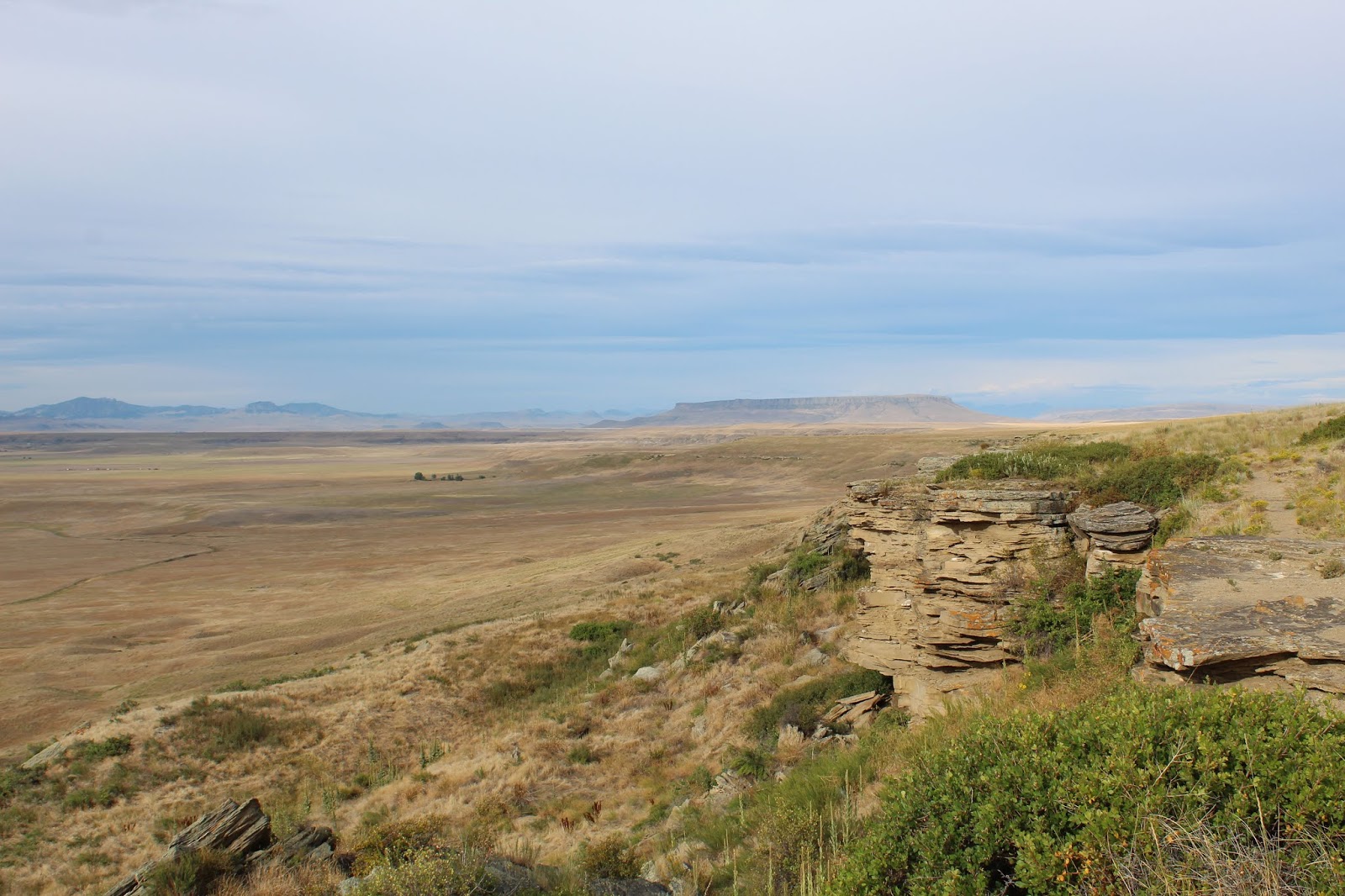
This was the first buffalo jump I had ever visited. We started off up on the top overlook (Our GPS had directed us there first, instead of the main visitor center below). As we strolled along it was easy to see how bison could be confused. It really looked like a gentle slope down the prairie until the last few yards. At that point a mile long cliff stretched out in front of you. The American Indians who ran with the herd would leap over the edge and try to take shelter on ledges as hundreds or thousands of bison fell to their death & injury below. Once the run was over, the tribes would butcher and clean the animals below the cliffs. Thousands upon thousands of remains have been excavated.
Despite the gruesome history and use of the area, it was quite a beautiful and cool morning. Amber and I spent time hiking along the bottom of the cliffs, and then walking along the top.
After wrapping up our time at the Interpretive Center we continued on to Giant Springs State Park. It sits just upstream and was a quick drive over. Lewis & Clark described it as what was surely the largest spring in the world, with the water so pure and clear it could still be discerned a mile down the river.
The water emerges on the bank, and some of it flows down into the river. The rest has been diverted to flow a few yards and then joins the river. It has been dubbed at one point the world's shortest river. The water has been traced to snow melt from the Little Belt Mountains about 30 miles to the south of Great Falls. And I'm not sure how they determined this, but they claim it takes 25 years for the melted snow to emerge from the spring. It stays a constant 51 degrees year round; so even in the dead of winter the area around the spring is pleasant.
After finishing up in town we ventured off the beaten path a bit to go see some more history. Our first stop was to "The Great Falls". It was the first waterfall Lewis & Clark would have encountered. We journeyed down some beat up roads before finally arriving at the site. Today there is a hydroelectric dam sitting above the falls, but you can still get a sense of what the expedition was faced with. There was no way to get a dugout canoe up those cascades.
After finishing up there, we continued on down the beaten path to reach a trail head parking for Sulphur Springs. Sulphur Springs is where the Lewis & Clark Expedition stopped and gave Sacagawea some of sulfurous spring water. She had been deathly ill for a period of the trip, and miraculously the spring water that was administered cured her. We, however, did not make it out to the spring. It was late in the afternoon and hot, so we opted to just hike to the overlook.
Down below, next to the river, is where the Lewis & Clark Expedition had made their camp while they debated what to do about the falls on the river. It was from this point that they started their 18 mile portage that took them almost a month. There was a lone cottonwood tree growing by the river that they cut down to form wheels with which to roll their canoes across the rugged landscape. And it wasn't just from point A to B. It involved numerous trips back and forth. All along the way you can still see the yucca and prickly pair cactus that covers the unforgiving landscape. The high June temperatures, cactus thorns stabbing into your feet and causing infections, and skin and fingers rubbed raw all contributed to the miserable month long experience. But these men were determined to push on at all costs.
At this point our day was winding down, and we went back into Great Falls to check into our Airbnb for the night. We got a good deal on our own private room in a couple's home. Their kids are all grown now, so they rent out their bedrooms. We even got a coffee maker, mini fridge/freezer, and microwave in our room so it worked out well for keeping our groceries cold. And after a quick jaunt to Perkins for dinner, we were able to warm up apple pie for dessert. The next morning we were up and off to First People's Buffalo Jump State Park. It was about 20 minutes outside of Great Falls.
This was the first buffalo jump I had ever visited. We started off up on the top overlook (Our GPS had directed us there first, instead of the main visitor center below). As we strolled along it was easy to see how bison could be confused. It really looked like a gentle slope down the prairie until the last few yards. At that point a mile long cliff stretched out in front of you. The American Indians who ran with the herd would leap over the edge and try to take shelter on ledges as hundreds or thousands of bison fell to their death & injury below. Once the run was over, the tribes would butcher and clean the animals below the cliffs. Thousands upon thousands of remains have been excavated.
Despite the gruesome history and use of the area, it was quite a beautiful and cool morning. Amber and I spent time hiking along the bottom of the cliffs, and then walking along the top.
After finishing up top, we made our way back down to the Visitor Center and explored the exhibits and learned more about the known details on the tribes that used the jump, the processes involved in herding the bison, and the history of the extermination of the bison on the American Continent. Then it was back on the road to head an hour south to the Little Belt Mountains...
Sunday, July 7, 2019
Holland Lake
This was our second weekend of camping, and we made the trip down to Holland Lake. It's a little over 1 1/2 hours southwest of Kalispell, sitting between the Swan Mountains to the East, and Mission Mountains to the West. Holland Lake is right at the foot of the Swan Range.
I had snagged one campsite in one of the two campgrounds located at Holland Lake, for Saturday night. The forecast called for thunderstorms, but we had already paid for the campsite so we were going to make the best of the situation. Saturday afternoon we had our best weather window, and got about 3 hours of good sunshine and some summer heat. We took this chance to drop the kayaks in the water and explore the lake.
We got back to shore just as another storm was rolling in. Thankfully we had already gotten camp set up, so we retreated into our tent to play games for a while. However, I was tired of not knowing when we'd be able to cook dinner so I set up my stove in the rain and made dinner. We got a momentary lapse in rain and got to eat outside before it picked up again.
Later that evening the rain cleared up again for about 3 hours, so I was able to get a campfire going and we enjoyed making s'mores. By the time we went to bed it began storming again and rained off and on throughout the night as more thunderstorms rolled through.
The next morning I scrubbed the plans to hike to Holland Falls because of little sleep and just wanting to get home to dry everything out. There is always next time.
I had snagged one campsite in one of the two campgrounds located at Holland Lake, for Saturday night. The forecast called for thunderstorms, but we had already paid for the campsite so we were going to make the best of the situation. Saturday afternoon we had our best weather window, and got about 3 hours of good sunshine and some summer heat. We took this chance to drop the kayaks in the water and explore the lake.
We got back to shore just as another storm was rolling in. Thankfully we had already gotten camp set up, so we retreated into our tent to play games for a while. However, I was tired of not knowing when we'd be able to cook dinner so I set up my stove in the rain and made dinner. We got a momentary lapse in rain and got to eat outside before it picked up again.
Later that evening the rain cleared up again for about 3 hours, so I was able to get a campfire going and we enjoyed making s'mores. By the time we went to bed it began storming again and rained off and on throughout the night as more thunderstorms rolled through.
The next morning I scrubbed the plans to hike to Holland Falls because of little sleep and just wanting to get home to dry everything out. There is always next time.
Sunday, June 30, 2019
Weekend Getaway in our Backyard
Knowing that I had three weeks free from being on call, Amber and I made plans to enjoy our weekends before mid-July when the risk of fire starts going up. I had been able to snag some last minute reservations in some campgrounds. I couldn't have gotten luckier. For our first free weekend, we were going to be staying at the Fish Creek Campground, in Glacier N.P.
We were up early Saturday morning to make it to the Lake MacDonald Lodge restaurant. One of Amber's birthday gifts was a meal at the lodge, so we stopped by for breakfast. Then we set out driving Going to the Sun Road, for our first time this year. We didn't care about stopping at Logan Pass, though. We continued down the East side until we found a parking spot to get us on the trail to Virginia Falls. Altogether, it was about 4 miles round trip.
After our nice hike we exited Saint Mary, and drove south. I wanted to check out the Cut Bank entrance of Glacier. It's accessed via a small gravel road. It ends at a small trail head parking and a primitive campground. It's definitely on my list of places I want to camp.
There were still a couple open campsites, but nowhere to park at the trail head. So we turned around and headed out, going back into the park at Saint Mary, driving across Logan Pass again, and made it to Apgar. From there it was a quick jaunt to the other side of Lake MacDonald to reach Fish Creek Campground. We ended up getting lucky with the campsite I had booked. It was in one of the smaller loops and sat right next to Fish Creek. We were able to hear the flowing water all night long.
After setting up camp we did the hike out to Rocky Point, enjoyed the warm sun and views of the mountains and the lake, and completed a loop back to the campground. We spent the rest of the day reading in the shade, roasting brats & smores over a camp fire, and going to a Ranger talk later that night about the bats that live in Glacier N.P.
We were up early Saturday morning to make it to the Lake MacDonald Lodge restaurant. One of Amber's birthday gifts was a meal at the lodge, so we stopped by for breakfast. Then we set out driving Going to the Sun Road, for our first time this year. We didn't care about stopping at Logan Pass, though. We continued down the East side until we found a parking spot to get us on the trail to Virginia Falls. Altogether, it was about 4 miles round trip.
After our nice hike we exited Saint Mary, and drove south. I wanted to check out the Cut Bank entrance of Glacier. It's accessed via a small gravel road. It ends at a small trail head parking and a primitive campground. It's definitely on my list of places I want to camp.
There were still a couple open campsites, but nowhere to park at the trail head. So we turned around and headed out, going back into the park at Saint Mary, driving across Logan Pass again, and made it to Apgar. From there it was a quick jaunt to the other side of Lake MacDonald to reach Fish Creek Campground. We ended up getting lucky with the campsite I had booked. It was in one of the smaller loops and sat right next to Fish Creek. We were able to hear the flowing water all night long.
After setting up camp we did the hike out to Rocky Point, enjoyed the warm sun and views of the mountains and the lake, and completed a loop back to the campground. We spent the rest of the day reading in the shade, roasting brats & smores over a camp fire, and going to a Ranger talk later that night about the bats that live in Glacier N.P.
Sunday, June 16, 2019
Whitefish Mountain Wilderness
Sunday June 16, 2019- After church Amber and I wanted to make use of our Sunday afternoon. We had just gotten our fishing licenses and were itching to start trying to catch fish for the summer. We drove up to Whitefish Lake and took a road heading up into the Whitefish Mountains. It's a remote range that runs along the boundary of Glacier National Park. The North Fork of the Flathead River provides the barrier between the range in Glacier, and the Whitefish.
An hour later, and plenty of dust and bumpy ruts later, we were deep into the mountains and ominous thunderclouds loomed above. We pulled into the small camping area at Upper Whitefish Lake just as a torrential downpour began. We sat in our van eating our lunch and watching the rain splatter across the lake and surrounding terrain. Thirty minutes later the sun came out, the rain began to subside, and we commenced fishing for a while.
Most of the lake shore isn't accessible very easily, except in a couple of the campsites and the area we pulled off the road. So after a while of not getting any trout to take our lures we continued up the narrow gravel road heading towards Red Meadow Lake.
Red Meadow Lake sits almost on top of the Whitefish Divide. I didn't realize how high up the lake sat, when I researched. It was in a small basin surrounded by towering rocky peaks. I was awestruck. We went to the eastern side of the lake and I spent some time trying to catch fish while Amber took pictures.
I didn't even get a bite. Not really surprised anymore. I have a several year bad streak of never catching fish. So we eventually packed up and headed down the east slope of the mountains until we reached the North Fork of the Flathead River. We skirted along outside Glacier N.P. before heading back to Columbia Falls and then home in Kalispell.
An hour later, and plenty of dust and bumpy ruts later, we were deep into the mountains and ominous thunderclouds loomed above. We pulled into the small camping area at Upper Whitefish Lake just as a torrential downpour began. We sat in our van eating our lunch and watching the rain splatter across the lake and surrounding terrain. Thirty minutes later the sun came out, the rain began to subside, and we commenced fishing for a while.
Most of the lake shore isn't accessible very easily, except in a couple of the campsites and the area we pulled off the road. So after a while of not getting any trout to take our lures we continued up the narrow gravel road heading towards Red Meadow Lake.
Red Meadow Lake sits almost on top of the Whitefish Divide. I didn't realize how high up the lake sat, when I researched. It was in a small basin surrounded by towering rocky peaks. I was awestruck. We went to the eastern side of the lake and I spent some time trying to catch fish while Amber took pictures.
Sunday, June 2, 2019
Late Spring in Glacier National Park
Early Sunday morning, on June 2, Amber and I were up early to drive to the east side of Glacier National Park. We wanted to hike to Virginia Falls, which is accessed from Going to the Sun Road. Because the full road is not open yet, we took HWY 2 around the southern boundary of the park. One of the neat features you pass on this route, is the lowest point on the Continental Divide, in the northern part of the US. It's named Marias Pass. American Indians long knew of the pass, but white settlers in America only heard rumors. In December of 1889 John Stevens set out on snow-shoes to explore the area and confirm that there was a feasible route for the Great Northern Railroad to cross the Continental Divide. The US HWY 2 wasn't constructed until the 1930s. At that time, a monument was put up at the location, honoring John Stevens.
When we got to East Glacier, we turned onto MT-49. It's a cut off road that gets you to the Two Medicine entrance of Glacier, and joins back up with MT-89 to then access the east side of Going to the Sun Road, at Saint Mary. It's a very handy shortcut, otherwise you have to go all the way over to Browning, MT to get to MT-89.
We got to the Two Medicine Entrance and discovered that route 49 was closed off. I didn't want to add even more driving time, so we decided to change our plans and hike some trails in Two Medicine. We parked the car and then began hiking along the south part of Middle Two Medicine Lake. It was a gorgeous morning and very peaceful. In addition to autumn, late spring is a wonderful time to visit the Park, before hordes of tourists descend upon Montana like swarms of locusts.
We passed beaver dams, beautiful meadows, and lots of early blooming wild flowers on our hike up the valley.
We reached a junction for Aster Falls, only 0.1 miles. So we made the quick jaunt to it. The sun was almost directly overhead the waterfall, so I struggled to get some good photos. It took a little bit of lighting adjustment at back at home.
It was very beautiful and roaring from all the spring run off. The cool mist felt pretty nice from the already hot morning. We continued down the main trail thinking we would try to make it to Rockwell Falls. However, when we neared Paradise Creek we ran into another couple who said the hiker bridge hadn't been put back in place yet for the season, and the water was too strong and deep to cross safely. A bit farther downstream was another crossing designed for horses, so we figured the four of us would take a look. However, once again, the water was just too swift to safely cross.
At that point, Amber and I decided to return to Aster Falls and continue up the trail 0.6 miles to Aster Lookout. It was steep going, but we made it and enjoyed some time soaking in the scenery and warm sun. We ran into only a handful of other hikers. How often can you say that when you go hiking in Glacier National Park on a warm sunny day?
I was able to set the camera up on a small rock ledge and even get a picture of the two of us before we headed back down the trail.
Once back down at the trail head we enjoyed a picnic lunch before we made the drive back to Kalispell. Until our next adventure...
We got to the Two Medicine Entrance and discovered that route 49 was closed off. I didn't want to add even more driving time, so we decided to change our plans and hike some trails in Two Medicine. We parked the car and then began hiking along the south part of Middle Two Medicine Lake. It was a gorgeous morning and very peaceful. In addition to autumn, late spring is a wonderful time to visit the Park, before hordes of tourists descend upon Montana like swarms of locusts.
We passed beaver dams, beautiful meadows, and lots of early blooming wild flowers on our hike up the valley.
We reached a junction for Aster Falls, only 0.1 miles. So we made the quick jaunt to it. The sun was almost directly overhead the waterfall, so I struggled to get some good photos. It took a little bit of lighting adjustment at back at home.
It was very beautiful and roaring from all the spring run off. The cool mist felt pretty nice from the already hot morning. We continued down the main trail thinking we would try to make it to Rockwell Falls. However, when we neared Paradise Creek we ran into another couple who said the hiker bridge hadn't been put back in place yet for the season, and the water was too strong and deep to cross safely. A bit farther downstream was another crossing designed for horses, so we figured the four of us would take a look. However, once again, the water was just too swift to safely cross.
At that point, Amber and I decided to return to Aster Falls and continue up the trail 0.6 miles to Aster Lookout. It was steep going, but we made it and enjoyed some time soaking in the scenery and warm sun. We ran into only a handful of other hikers. How often can you say that when you go hiking in Glacier National Park on a warm sunny day?
Once back down at the trail head we enjoyed a picnic lunch before we made the drive back to Kalispell. Until our next adventure...
Subscribe to:
Posts (Atom)